Cherry Orchard night lights from space
Night Light of Cherry Orchard (Leinster) from space (Ireland) Src. Average luminocity for 10x10km area is 92.6149% and for 50x50km: 24.6593%.
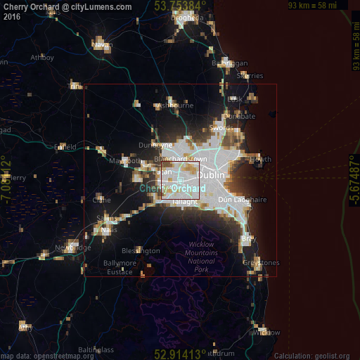
Analysis of Cherry Orchard night lights 2016
Square area 10x10 km:
 41.04%
90-99
35.35%80-89
10.98%70-79
5.56%60-69
1.01%50-59
2.4%40-49
3.41%30-39
0.25%20-29
0%10-19
0%0-9
0%Square area 50x50 km:
8.22%90-99
5.5%80-89
1.81%70-79
1.92%60-69
1.81%50-59
1.8%40-49
2.36%30-39
2.77%20-29
5.23%10-19
11.18%0-9
57.4%Clear (daylight) street map image can be seen on geolist.org.
Map coordinates:
53° 45' 13.8" North, 7° 4' 52" West
53° 20' 9.8" North, 6° 22' 40.8" West
52° 54' 50.9" North, 5° 40' 29.5" West
Some cities around Cherry Orchard sort by population:
• Lucan
5.3 km =3.3 mi,  296°
296°
• Clondalkin
1.8 km =1.1 mi,  224°
224°
• Crumlin
4.5 km =2.8 mi,  110°
110°
• Ballyfermot
1.7 km =1.1 mi,  63°
63°
• Castleknock
4.4 km =2.7 mi,  12°
12°
• Palmerstown
1.6 km =1 mi,  0°
0°
• Greenhills
5 km =3.1 mi,  91°
91°
• Chapelizod
2.7 km =1.7 mi, 59°
6619871 (p: 7,924)
Sources (retrieved 2019-11-25):
» Earth at Night: Flat Maps 2012, 2016