Confey night lights from space
Night Light of Confey (Leinster) from space (Ireland) Src. Average luminocity for 10x10km area is 49.9775% and for 50x50km: 24.6568%.
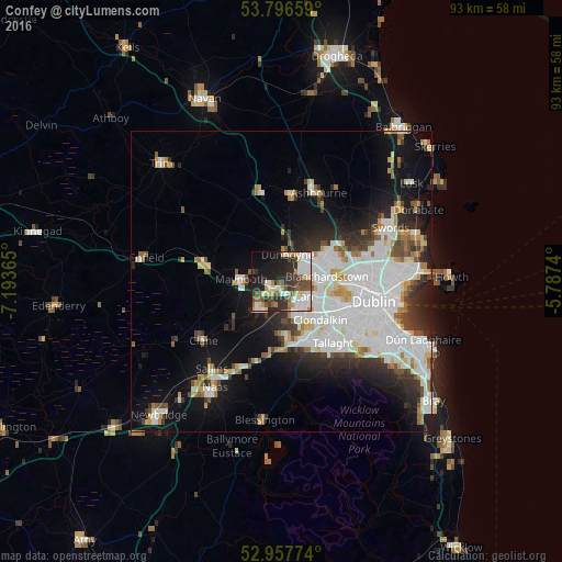
Analysis of Confey night lights 2016
Square area 10x10 km:
 10.85%
90-99
11.51%80-89
6.35%70-79
3.44%60-69
5.16%50-59
6.48%40-49
9.52%30-39
7.14%20-29
12.43%10-19
19.84%0-9
7.28%Square area 50x50 km:
8.34%90-99
5.57%80-89
1.86%70-79
1.95%60-69
1.86%50-59
1.7%40-49
2.25%30-39
2.73%20-29
4.91%10-19
10.42%0-9
58.39%Clear (daylight) street map image can be seen on geolist.org.
Map coordinates:
53° 47' 47.7" North, 7° 11' 37.1" West
53° 22' 45.2" North, 6° 29' 25.9" West
52° 57' 27.9" North, 5° 47' 14.6" West
Some cities around Confey sort by population:
• Celbridge
5.5 km =3.4 mi,  220°
220°
• Blanchardstown
7.7 km =4.8 mi,  82°
82°
• Leixlip
1.5 km =0.9 mi,  192°
192°
• Lucan
3.7 km =2.3 mi,  131°
131°
• Maynooth
6.9 km =4.3 mi,  275°
275°
• Palmerstown
8.1 km =5 mi,  113°
113°
• Dunboyne
4.6 km =2.9 mi,  14°
14°
• Hartstown
4.5 km =2.8 mi,  69°
69°
7870938 (p: 5,389)
Sources (retrieved 2019-11-25):
» Earth at Night: Flat Maps 2012, 2016