Hajdúhadház night lights from space
Night Light of Hajdúhadház (Hajdú-Bihar) from space (Hungary) Src. Average luminocity for 10x10km area is 3.8557% and for 50x50km: 4.4318%.
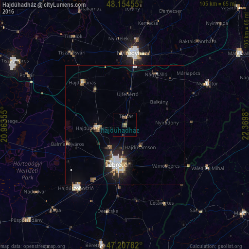
Analysis of Hajdúhadház night lights 2016
Square area 10x10 km:
 0%
0%90-99
0%80-89
0%70-79
0.45%60-69
1.34%50-59
0.3%40-49
2.98%30-39
1.93%20-29
0.15%10-19
0%0-9
92.86%Square area 50x50 km:
0.68%90-99
0.75%80-89
0.43%70-79
0.48%60-69
0.38%50-59
0.51%40-49
0.82%30-39
0.57%20-29
1.26%10-19
2.77%0-9
91.35%Clear (daylight) street map image can be seen on geolist.org.
Map coordinates:
48° 9' 16.4" North, 20° 57' 48.8" East
47° 40' 60" North, 21° 40' 0" East
47° 12' 28.2" North, 22° 22' 11.3" East
Some cities around Hajdúhadház sort by population:
• Debrecen
16.9 km =10.5 mi,  188°
188°
• Balmazújváros
24.9 km =15.5 mi,  252°
252°
• Újfehértó
13 km =8.1 mi,  5°
5°
• Nagykálló
25 km =15.5 mi,  31°
31°
• Nyíradony
18.9 km =11.7 mi,  85°
85°
• Balkány
17.6 km =10.9 mi,  56°
56°
• Téglás
3.9 km =2.4 mi,  18°
18°
• Vámospércs
24.2 km =15 mi,  133°
133°
720287 (p: 12,892)
Sources (retrieved 2019-11-25):
» Earth at Night: Flat Maps 2012, 2016