Vámospércs night lights from space
Night Light of Vámospércs (Hajdú-Bihar) from space (Hungary) Src. Average luminocity for 10x10km area is 0.5838% and for 50x50km: 3.3281%.
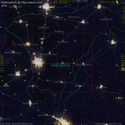
Analysis of Vámospércs night lights 2016
Square area 10x10 km:
 0%
0%90-99
0%80-89
0%70-79
0%60-69
0%50-59
0.57%40-49
0%30-39
0.28%20-29
0.28%10-19
0.14%0-9
98.72%Square area 50x50 km:
0.56%90-99
0.66%80-89
0.35%70-79
0.35%60-69
0.23%50-59
0.38%40-49
0.62%30-39
0.42%20-29
1.19%10-19
2.14%0-9
93.11%Clear (daylight) street map image can be seen on geolist.org.
Map coordinates:
48° 0' 21.3" North, 21° 11' 48.8" East
47° 31' 60" North, 21° 54' 0" East
47° 3' 23.3" North, 22° 36' 11.3" East
Some cities around Vámospércs sort by population:
• Debrecen
20 km =12.4 mi,  270°
270°
• Hajdúhadház
24.2 km =15 mi,  313°
313°
• Hajdúsámson
12.5 km =7.8 mi, 306°
• Valea lui Mihai, RO
18.9 km =11.7 mi,  95°
95°
• Nyíradony
18.3 km =11.4 mi,  4°
4°
• Létavértes
16.7 km =10.4 mi,  180°
180°
• Săcueni, RO
25.3 km =15.7 mi,  143°
143°
• Hosszúpályi
20 km =12.4 mi,  218°
218°
714265 (p: 5,451)
Sources (retrieved 2019-11-25):
» Earth at Night: Flat Maps 2012, 2016