Újfehértó night lights from space
Night Light of Újfehértó (Szabolcs-Szatmár-Bereg) from space (Hungary) Src. Average luminocity for 10x10km area is 0.6726% and for 50x50km: 3.6679%.
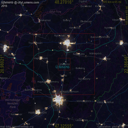
Analysis of Újfehértó night lights 2016
Square area 10x10 km:
 0%
0%90-99
0%80-89
0%70-79
0%60-69
0%50-59
0.74%40-49
0.45%30-39
0%20-29
0%10-19
0%0-9
98.81%Square area 50x50 km:
0.5%90-99
0.52%80-89
0.32%70-79
0.28%60-69
0.37%50-59
0.49%40-49
0.63%30-39
0.62%20-29
1.16%10-19
2.88%0-9
92.24%Clear (daylight) street map image can be seen on geolist.org.
Map coordinates:
48° 16' 12.6" North, 20° 58' 48.8" East
47° 48' 0" North, 21° 40' 60" East
47° 19' 32" North, 22° 23' 11.3" East
Some cities around Újfehértó sort by population:
• Nyíregyháza
17.5 km =10.9 mi,  8°
8°
• Hajdúböszörmény
19.4 km =12.1 mi,  220°
220°
• Hajdúnánás
19.5 km =12.1 mi,  286°
286°
• Hajdúhadház
13 km =8.1 mi,  185°
185°
• Nagykálló
14.4 km =8.9 mi,  54°
54°
• Hajdúdorog
13.8 km =8.6 mi,  277°
277°
• Balkány
13.8 km =8.6 mi,  103°
103°
• Téglás
9.3 km =5.8 mi,  180°
180°
714464 (p: 13,542)
Sources (retrieved 2019-11-25):
» Earth at Night: Flat Maps 2012, 2016