Velika Gorica night lights from space
Night Light of Velika Gorica (Zagrebačka) from space (Croatia) Src. Average luminocity for 10x10km area is 49.0061% and for 50x50km: 23.9642%.
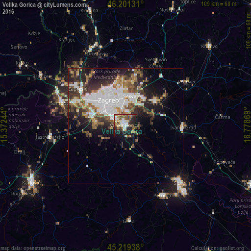
Analysis of Velika Gorica night lights 2016
Square area 10x10 km:
 7.12%
7.12%90-99
10.45%80-89
3.94%70-79
5.76%60-69
9.24%50-59
9.7%40-49
7.88%30-39
5.45%20-29
20.15%10-19
19.24%0-9
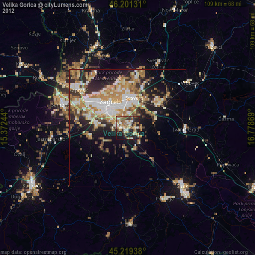
1.06%Square area 50x50 km:
6.52%90-99
4.35%80-89
1.75%70-79
2.01%60-69
3.31%50-59
3.14%40-49
2.96%30-39
4.14%20-29
6.55%10-19
9.13%0-9
56.15%Clear (daylight) street map image can be seen on geolist.org.
Map coordinates:
46° 12' 4.7" North, 15° 22' 20.8" East
45° 42' 45" North, 16° 4' 32" East
45° 13' 9.8" North, 16° 46' 43.3" East
Some cities around Velika Gorica sort by population:
• Zagreb
13.6 km =8.5 mi,  326°
326°
• Sesvete
13.6 km =8.5 mi,  13°
13°
• Stenjevec
18.4 km =11.4 mi,  305°
305°
• Centar
13.5 km =8.4 mi, 325°
• Zaprešić
26.2 km =16.3 mi, 307°
• Samobor
29.5 km =18.3 mi,  289°
289°
• Brezovica
12.9 km =8 mi,  278°
278°
• Jastrebarsko
33.5 km =20.8 mi,  261°
261°
3188244 (p: 35,072)
Sources (retrieved 2019-11-25):
» Earth at Night: Flat Maps 2012, 2016