Samobor night lights from space
Night Light of Samobor (Zagrebačka) from space (Croatia) Src. Average luminocity for 10x10km area is 44.6473% and for 50x50km: 18.8143%.
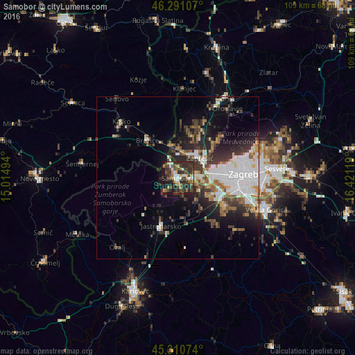
Analysis of Samobor night lights 2016
Square area 10x10 km:
 6.25%
6.25%90-99
5.65%80-89
2.98%70-79
5.21%60-69
6.55%50-59
6.7%40-49
11.31%30-39
17.26%20-29
21.88%10-19
15.03%0-9
1.19%Square area 50x50 km:
5.03%90-99
3.24%80-89
1.19%70-79
1.57%60-69
2.21%50-59
2.23%40-49
2.71%30-39
3.63%20-29
5.72%10-19
7.34%0-9
65.12%Clear (daylight) street map image can be seen on geolist.org.
Map coordinates:
46° 17' 27.9" North, 15° 0' 53.8" East
45° 48' 11" North, 15° 43' 5" East
45° 18' 38.7" North, 16° 25' 16.3" East
Some cities around Samobor sort by population:
• Zagreb
20.2 km =12.6 mi,  86°
86°
• Stenjevec
12.8 km =8 mi, 87°
• Centar
20.1 km =12.5 mi, 86°
• Zaprešić
9.1 km =5.7 mi,  49°
49°
• Brezovica
17.1 km =10.6 mi,  118°
118°
• Brežice, SI
14.9 km =9.3 mi,  318°
318°
• Jastrebarsko
15.9 km =9.9 mi,  199°
199°
• Kostanjevica na Krki, SI
23.4 km =14.5 mi,  281°
281°
3191316 (p: 15,221)
Sources (retrieved 2019-11-25):
» Earth at Night: Flat Maps 2012, 2016