Brezovica night lights from space
Night Light of Brezovica (City of Zagreb) from space (Croatia) Src. Average luminocity for 10x10km area is 48.6348% and for 50x50km: 25.6988%.
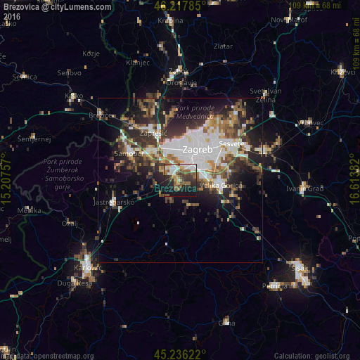
Analysis of Brezovica night lights 2016
Square area 10x10 km:
 11.36%
90-99
7.73%80-89
2.42%70-79
6.06%60-69
6.21%50-59
11.67%40-49
7.88%30-39
7.88%20-29
12.42%10-19
25.45%0-9
0.91%Square area 50x50 km:
6.56%90-99
4.49%80-89
1.73%70-79
2.11%60-69
3.46%50-59
3.57%40-49
3.78%30-39
4.58%20-29
8.04%10-19
10.29%0-9
51.39%Clear (daylight) street map image can be seen on geolist.org.
Map coordinates:
46° 13' 4.3" North, 15° 12' 27.3" East
45° 43' 45.1" North, 15° 54' 38.5" East
45° 14' 10.4" North, 16° 36' 49.8" East
Some cities around Brezovica sort by population:
• Zagreb
10.8 km =6.7 mi,  28°
28°
• Sesvete
19.6 km =12.2 mi,  54°
54°
• Stenjevec
9.1 km =5.7 mi,  346°
346°
• Centar
10.7 km =6.6 mi, 29°
• Velika Gorica
12.9 km =8 mi,  98°
98°
• Zaprešić
16.2 km =10.1 mi,  330°
330°
• Samobor
17.1 km =10.6 mi,  298°
298°
• Jastrebarsko
21.4 km =13.3 mi,  251°
251°
3203344 (p: 10,884)
Sources (retrieved 2019-11-25):
» Earth at Night: Flat Maps 2012, 2016