Kostanjevica na Krki night lights from space
Night Light of Kostanjevica na Krki from space (Slovenia) Src. Average luminocity for 10x10km area is 0.1086% and for 50x50km: 4.6002%.
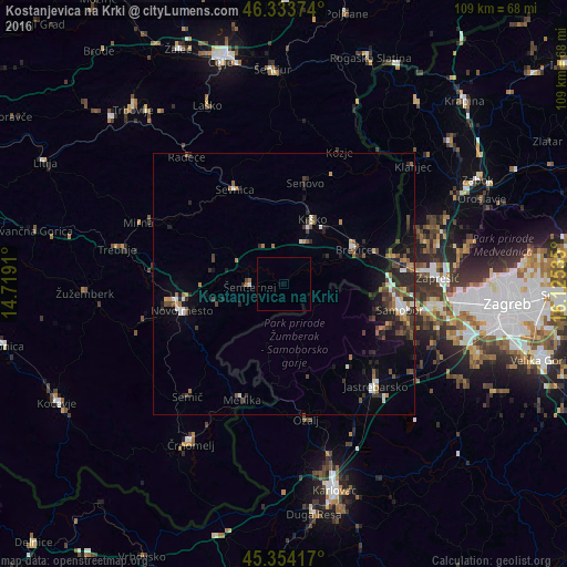
Analysis of Kostanjevica na Krki night lights 2016
Square area 10x10 km:
 0%
0%90-99
0%80-89
0%70-79
0%60-69
0%50-59
0%40-49
0%30-39
0%20-29
0%10-19
0%0-9
100%Square area 50x50 km:
0.45%90-99
0.64%80-89
0.2%70-79
0.4%60-69
0.64%50-59
0.75%40-49
1.13%30-39
0.81%20-29
1.79%10-19
2.53%0-9
90.67%Clear (daylight) street map image can be seen on geolist.org.
Map coordinates:
46° 20' 1.5" North, 14° 43' 8.8" East
45° 50' 46" North, 15° 25' 20" East
45° 21' 15" North, 16° 7' 31.3" East
Some cities around Kostanjevica na Krki sort by population:
• Novo Mesto
20.2 km =12.6 mi,  256°
256°
• Samobor, HR
23.4 km =14.5 mi,  101°
101°
• Krško
13.7 km =8.5 mi,  23°
23°
• Brežice
14.5 km =9 mi,  64°
64°
• Sevnica
19.8 km =12.3 mi,  335°
335°
• Šentjernej
6.7 km =4.2 mi, 264°
• Šmarjeta
14 km =8.7 mi,  287°
287°
• Škocjan
12.2 km =7.6 mi,  303°
303°
3197581 (p: 695)
Sources (retrieved 2019-11-25):
» Earth at Night: Flat Maps 2012, 2016