Labin night lights from space
Night Light of Labin (Istria) from space (Croatia) Src. Average luminocity for 10x10km area is 18.3636% and for 50x50km: 4.0121%.
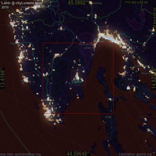
Analysis of Labin night lights 2016
Square area 10x10 km:
100  1.06%
1.06%
90-99 5.61%
80-89 2.42%
70-79 1.82%
60-69 0.61%
50-59 1.97%
40-49 1.67%
30-39 0.76%
20-29 3.79%
10-19 13.94%
0-9 66.36%
1.06%90-99
5.61%80-89
2.42%70-79
1.82%60-69
0.61%50-59
1.97%40-49
1.67%30-39
0.76%20-29
3.79%10-19
13.94%0-9
66.36%Square area 50x50 km:
100 0.34%
90-99 0.64%
80-89 0.49%
70-79 0.36%
60-69 0.49%
50-59 0.62%
40-49 0.37%
30-39 0.53%
20-29 1.4%
10-19 3.17%
0-9 91.59%
0.34%90-99
0.64%80-89
0.49%70-79
0.36%60-69
0.49%50-59
0.62%40-49
0.37%30-39
0.53%20-29
1.4%10-19
3.17%0-9
91.59%Clear (daylight) street map image can be seen on geolist.org.
Map coordinates:
45° 35' 21.1" North, 13° 24' 59.8" East
45° 5' 42" North, 14° 7' 11" East
44° 35' 47.3" North, 14° 49' 22.3" East
Some cities around Labin sort by population:
• Rijeka
36.1 km =22.4 mi,  44°
44°
• Pula
33 km =20.5 mi,  220°
220°
• Rovinj
38.1 km =23.7 mi,  267°
267°
• Poreč
43.6 km =27.1 mi,  289°
289°
• Opatija
30.6 km =19 mi,  28°
28°
• Drenova
37.4 km =23.2 mi, 40°
• Buzet
37 km =23 mi,  341°
341°
• Pazin
21.6 km =13.4 mi,  318°
318°
3196834 (p: 7,943)
Sources (retrieved 2019-11-25):
» Earth at Night: Flat Maps 2012, 2016