Drenova night lights from space
Night Light of Drenova (Primorsko-Goranska) from space (Croatia) Src. Average luminocity for 10x10km area is 58.0873% and for 50x50km: 8.2043%.
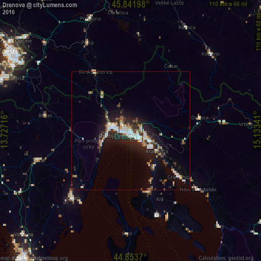
Analysis of Drenova night lights 2016
Square area 10x10 km:
 16.19%
90-99
13.65%80-89
6.83%70-79
4.44%60-69
5.87%50-59
5.08%40-49
5.08%30-39
10.32%20-29
24.76%10-19
7.62%0-9
0.16%Square area 50x50 km:
1.28%90-99
1.37%80-89
0.83%70-79
0.49%60-69
0.84%50-59
1.05%40-49
1.13%30-39
1.18%20-29
3.3%10-19
5.74%0-9
82.8%Clear (daylight) street map image can be seen on geolist.org.
Map coordinates:
45° 50' 31.1" North, 13° 43' 37.8" East
45° 21' 0" North, 14° 25' 49" East
44° 51' 13.3" North, 15° 8' 0.3" East
Some cities around Drenova sort by population:
• Rijeka
2.8 km =1.7 mi,  159°
159°
• Opatija
9.9 km =6.2 mi,  262°
262°
• Crikvenica
28.1 km =17.5 mi,  133°
133°
• Buzet
36.8 km =22.9 mi,  280°
280°
• Novi Vinodolski
37.4 km =23.2 mi, 131°
• Ilirska Bistrica, SI
28.2 km =17.5 mi,  329°
329°
• Leskova Dolina, SI
30.3 km =18.8 mi,  4°
4°
• Osilnica, SI
28.9 km =18 mi,  46°
46°
3201217 (p: 7,638)
Sources (retrieved 2019-11-25):
» Earth at Night: Flat Maps 2012, 2016