Buzet night lights from space
Night Light of Buzet (Istria) from space (Croatia) Src. Average luminocity for 10x10km area is 2.781% and for 50x50km: 5.5677%.
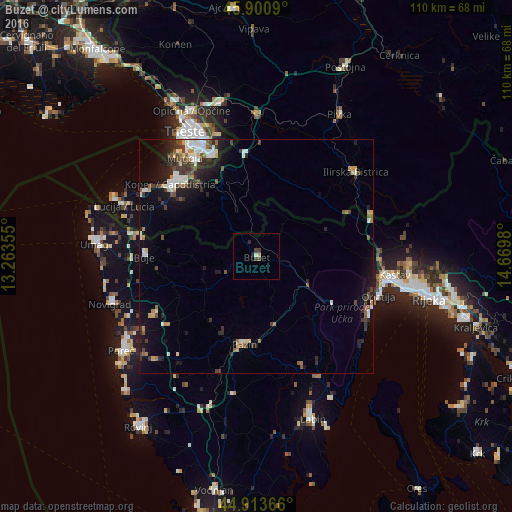
Analysis of Buzet night lights 2016
Square area 10x10 km:
 0%
0%90-99
0.63%80-89
0%70-79
0.63%60-69
0%50-59
0%40-49
0.95%30-39
1.59%20-29
1.11%10-19
0.16%0-9
94.92%Square area 50x50 km:
0.69%90-99
1.15%80-89
0.31%70-79
0.49%60-69
0.5%50-59
0.69%40-49
0.96%30-39
1.31%20-29
1.42%10-19
3.45%0-9
89.03%Clear (daylight) street map image can be seen on geolist.org.
Map coordinates:
45° 54' 3.2" North, 13° 15' 48.8" East
45° 24' 34" North, 13° 58' 0" East
44° 54' 49.2" North, 14° 40' 11.3" East
Some cities around Buzet sort by population:
• Koper, SI
24 km =14.9 mi,  309°
309°
• Izola, SI
27.7 km =17.2 mi,  300°
300°
• Muggia, IT
26.6 km =16.5 mi,  324°
324°
• Opatija
27.6 km =17.1 mi,  106°
106°
• Pazin
19 km =11.8 mi,  187°
187°
• Ilirska Bistrica, SI
28 km =17.4 mi,  51°
51°
• Ankaran, SI
26 km =16.2 mi, 316°
• Kozina, SI
22.4 km =13.9 mi,  353°
353°
3202942 (p: 6,059)
Sources (retrieved 2019-11-25):
» Earth at Night: Flat Maps 2012, 2016