Pazin night lights from space
Night Light of Pazin (Istria) from space (Croatia) Src. Average luminocity for 10x10km area is 7.5288% and for 50x50km: 4.416%.
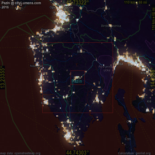
Analysis of Pazin night lights 2016
Square area 10x10 km:
100  0%
0%
90-99 1.21%
80-89 1.67%
70-79 0.76%
60-69 1.82%
50-59 1.21%
40-49 0.15%
30-39 1.21%
20-29 1.52%
10-19 0.76%
0-9 89.7%
0%90-99
1.21%80-89
1.67%70-79
0.76%60-69
1.82%50-59
1.21%40-49
0.15%30-39
1.21%20-29
1.52%10-19
0.76%0-9
89.7%Square area 50x50 km:
100 0.2%
90-99 0.84%
80-89 0.53%
70-79 0.47%
60-69 0.54%
50-59 0.43%
40-49 0.53%
30-39 0.58%
20-29 1.09%
10-19 2.93%
0-9 91.85%
0.2%90-99
0.84%80-89
0.53%70-79
0.47%60-69
0.54%50-59
0.43%40-49
0.53%30-39
0.58%20-29
1.09%10-19
2.93%0-9
91.85%Clear (daylight) street map image can be seen on geolist.org.
Map coordinates:
45° 43' 59.6" North, 13° 14' 0.8" East
45° 14' 25" North, 13° 56' 12" East
44° 44' 34.9" North, 14° 38' 23.3" East
Some cities around Pazin sort by population:
• Koper, SI
37.7 km =23.4 mi,  334°
334°
• Rovinj
29.5 km =18.3 mi,  233°
233°
• Izola, SI
39.3 km =24.4 mi, 326°
• Poreč
26.8 km =16.7 mi,  266°
266°
• Labin
21.6 km =13.4 mi,  138°
138°
• Opatija
30.8 km =19.1 mi,  69°
69°
• Umag
38.6 km =24 mi,  303°
303°
• Buzet
19 km =11.8 mi,  7°
7°
3193561 (p: 5,010)
Sources (retrieved 2019-11-25):
» Earth at Night: Flat Maps 2012, 2016