Opatija night lights from space
Night Light of Opatija (Primorsko-Goranska) from space (Croatia) Src. Average luminocity for 10x10km area is 34.0063% and for 50x50km: 7.7706%.
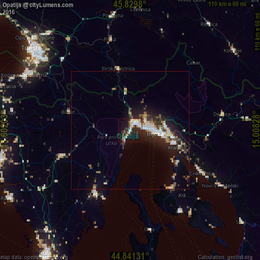
Analysis of Opatija night lights 2016
Square area 10x10 km:
 7.3%
7.3%90-99
6.83%80-89
3.65%70-79
1.27%60-69
4.13%50-59
3.49%40-49
3.65%30-39
5.24%20-29
12.7%10-19
26.35%0-9
25.4%Square area 50x50 km:
1.21%90-99
1.26%80-89
0.73%70-79
0.48%60-69
0.82%50-59
1.17%40-49
1.11%30-39
1.15%20-29
3.03%10-19
5.73%0-9
83.3%Clear (daylight) street map image can be seen on geolist.org.
Map coordinates:
45° 49' 47.3" North, 13° 36' 7.3" East
45° 20' 15.8" North, 14° 18' 18.5" East
44° 50' 28.7" North, 15° 0' 29.8" East
Some cities around Opatija sort by population:
• Rijeka
10.8 km =6.7 mi,  96°
96°
• Labin
30.6 km =19 mi,  208°
208°
• Drenova
9.9 km =6.2 mi,  82°
82°
• Crikvenica
35.2 km =21.9 mi,  120°
120°
• Buzet
27.6 km =17.1 mi,  286°
286°
• Pazin
30.8 km =19.1 mi,  249°
249°
• Ilirska Bistrica, SI
26 km =16.2 mi,  349°
349°
• Leskova Dolina, SI
33.8 km =21 mi,  21°
21°
3194099 (p: 7,888)
Sources (retrieved 2019-11-25):
» Earth at Night: Flat Maps 2012, 2016