Ivanec night lights from space
Night Light of Ivanec (Varaždinska) from space (Croatia) Src. Average luminocity for 10x10km area is 8.1086% and for 50x50km: 6.3187%.
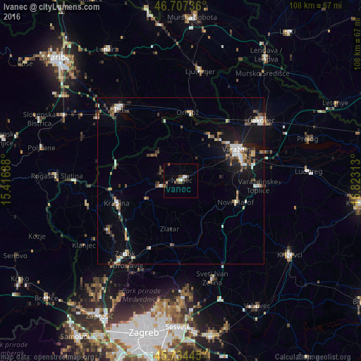
Analysis of Ivanec night lights 2016
Square area 10x10 km:
 1.19%
1.19%90-99
1.04%80-89
0.15%70-79
0.6%60-69
1.34%50-59
1.19%40-49
2.98%30-39
0.15%20-29
1.79%10-19
1.04%0-9
88.54%Square area 50x50 km:
0.9%90-99
0.92%80-89
0.52%70-79
0.61%60-69
0.52%50-59
1.04%40-49
0.89%30-39
1.04%20-29
1.22%10-19
4.71%0-9
87.63%Clear (daylight) street map image can be seen on geolist.org.
Map coordinates:
46° 42' 26.5" North, 15° 25' 0.8" East
46° 13' 23" North, 16° 7' 12" East
45° 44' 4" North, 16° 49' 23.3" East
Some cities around Ivanec sort by population:
• Varaždin
19 km =11.8 mi,  61°
61°
• Krapina
19.8 km =12.3 mi,  249°
249°
• Ormož, SI
21.1 km =13.1 mi,  7°
7°
• Središče ob Dravi, SI
22.2 km =13.8 mi,  30°
30°
• Gorišnica, SI
22.8 km =14.2 mi,  339°
339°
• Cirkulane, SI
16.5 km =10.3 mi,  324°
324°
• Podlehnik, SI
22.3 km =13.9 mi,  304°
304°
• Zavrč, SI
19.5 km =12.1 mi, 343°
3199076 (p: 5,461)
Sources (retrieved 2019-11-25):
» Earth at Night: Flat Maps 2012, 2016