Santa Rosa de Copán night lights from space
Night Light of Santa Rosa de Copán (Copán) from space (Honduras) Src. Average luminocity for 10x10km area is 23.7645% and for 50x50km: 2.3067%.
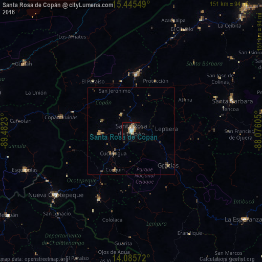
Analysis of Santa Rosa de Copán night lights 2016
Square area 10x10 km:
 4.34%
4.34%90-99
3.72%80-89
1.03%70-79
3.93%60-69
4.13%50-59
2.69%40-49
1.45%30-39
4.55%20-29
2.48%10-19
16.74%0-9
54.96%Square area 50x50 km:
0.17%90-99
0.18%80-89
0.21%70-79
0.38%60-69
0.41%50-59
0.29%40-49
0.41%30-39
0.65%20-29
0.51%10-19
0.96%0-9
95.82%Clear (daylight) street map image can be seen on geolist.org.
Map coordinates:
15° 26' 43.8" North, 89° 28' 56.3" West
14° 46' 0" North, 88° 46' 45" West
14° 5' 8.6" North, 88° 4' 33.8" West
Some cities around Santa Rosa de Copán sort by population:
• Esquipulas, GT
65.5 km =40.7 mi,  250°
250°
• La Entrada
31.9 km =19.8 mi,  8°
8°
• Nueva Ocotepeque
57.1 km =35.5 mi,  229°
229°
• Gracias
28.9 km =18 mi,  132°
132°
• Copán
40.5 km =25.2 mi,  280°
280°
• San Luis
55.2 km =34.3 mi,  50°
50°
• San Marcos
44.7 km =27.8 mi,  204°
204°
• Florida
30.2 km =18.8 mi,  348°
348°
3601494 (p: 27,753)
Sources (retrieved 2019-11-25):
» Earth at Night: Flat Maps 2012, 2016