San Luis night lights from space
Night Light of San Luis (Santa Bárbara) from space (Honduras) Src. Average luminocity for 10x10km area is 0% and for 50x50km: 1.3917%.
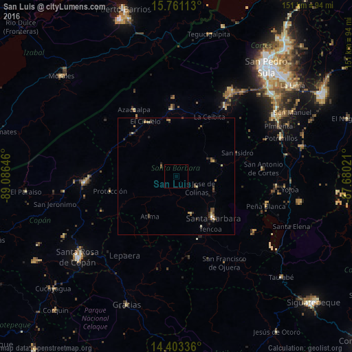
Analysis of San Luis night lights 2016
Square area 10x10 km:
 0%
0%90-99
0%80-89
0%70-79
0%60-69
0%50-59
0%40-49
0%30-39
0%20-29
0%10-19
0%0-9
100%Square area 50x50 km:
0.03%90-99
0.11%80-89
0.22%70-79
0.11%60-69
0.26%50-59
0.28%40-49
0.21%30-39
0.55%20-29
0.44%10-19
0.16%0-9
97.62%Clear (daylight) street map image can be seen on geolist.org.
Map coordinates:
15° 45' 40.1" North, 89° 5' 11.3" West
15° 4' 60" North, 88° 22' 60" West
14° 24' 12.1" North, 87° 40' 48.8" West
Some cities around San Luis sort by population:
• Villanueva
48.6 km =30.2 mi,  57°
57°
• Cofradía
43.2 km =26.8 mi,  35°
35°
• Potrerillos
47.7 km =29.6 mi,  69°
69°
• Santa Bárbara
24.1 km =15 mi,  139°
139°
• La Entrada
37.8 km =23.5 mi,  264°
264°
• Pimienta Vieja
47.7 km =29.6 mi, 69°
• Las Vegas, Santa Barbara
40.3 km =25 mi,  124°
124°
• Azacualpa
34.1 km =21.2 mi,  328°
328°
3601932 (p: 5,733)
Sources (retrieved 2019-11-25):
» Earth at Night: Flat Maps 2012, 2016