Baracoa night lights from space
Night Light of Baracoa (Cortés) from space (Honduras) Src. Average luminocity for 10x10km area is 15.855% and for 50x50km: 9.9085%.
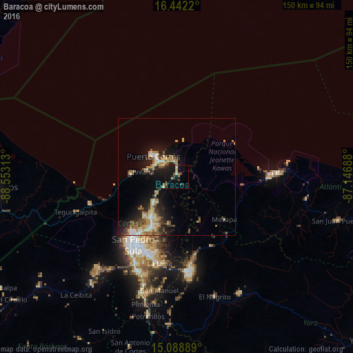
Analysis of Baracoa night lights 2016
Square area 10x10 km:
 0%
0%90-99
0.22%80-89
4.55%70-79
1.3%60-69
1.73%50-59
1.95%40-49
2.81%30-39
2.6%20-29
4.33%10-19
24.03%0-9
56.49%Square area 50x50 km:
0.75%90-99
1.45%80-89
1.61%70-79
1.42%60-69
1.62%50-59
1.54%40-49
1.27%30-39
1.45%20-29
2.6%10-19
7.18%0-9
79.11%Clear (daylight) street map image can be seen on geolist.org.
Map coordinates:
16° 26' 31.9" North, 88° 33' 11.3" West
15° 46' 0" North, 87° 51' 0" West
15° 5' 20" North, 87° 8' 48.8" West
Some cities around Baracoa sort by population:
• San Pedro Sula
34.7 km =21.6 mi,  212°
212°
• Choloma
20.2 km =12.6 mi, 213°
• El Progreso
41.1 km =25.5 mi,  172°
172°
• Puerto Cortez
10.8 km =6.7 mi,  307°
307°
• La Lima
37.7 km =23.4 mi,  190°
190°
• Tela
41 km =25.5 mi,  88°
88°
• Mezapa
29.6 km =18.4 mi,  133°
133°
• Cuyamel
39.1 km =24.3 mi,  253°
253°
3614872 (p: 9,202)
Sources (retrieved 2019-11-25):
» Earth at Night: Flat Maps 2012, 2016