Cuyamel night lights from space
Night Light of Cuyamel (Cortés) from space (Honduras) Src. Average luminocity for 10x10km area is 4.5671% and for 50x50km: 7.6677%.
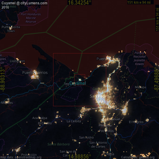
Analysis of Cuyamel night lights 2016
Square area 10x10 km:
 0%
0%90-99
0.43%80-89
2.16%70-79
1.3%60-69
0.43%50-59
0%40-49
0%30-39
0%20-29
0.87%10-19
0.87%0-9
93.94%Square area 50x50 km:
1.71%90-99
1.74%80-89
0.98%70-79
1.01%60-69
0.7%50-59
0.8%40-49
0.78%30-39
0.78%20-29
1.3%10-19
3.22%0-9
86.97%Clear (daylight) street map image can be seen on geolist.org.
Map coordinates:
16° 20' 33.1" North, 88° 54' 11.3" West
15° 40' 0" North, 88° 12' 0" West
14° 59' 18.8" North, 87° 29' 48.8" West
Some cities around Cuyamel sort by population:
• San Pedro Sula
26 km =16.2 mi,  133°
133°
• Choloma
27.1 km =16.8 mi,  102°
102°
• Puerto Barrios, GT
42.8 km =26.6 mi,  279°
279°
• Puerto Cortez
33.9 km =21.1 mi,  58°
58°
• La Lima
39.9 km =24.8 mi, 130°
• Villanueva
44.4 km =27.6 mi,  151°
151°
• Cofradía
30.1 km =18.7 mi,  169°
169°
• Baracoa
39.1 km =24.3 mi,  73°
73°
3612929 (p: 5,022)
Sources (retrieved 2019-11-25):
» Earth at Night: Flat Maps 2012, 2016