Sanarate night lights from space
Night Light of Sanarate (El Progreso) from space (Guatemala) Src. Average luminocity for 10x10km area is 9.4938% and for 50x50km: 2.9473%.
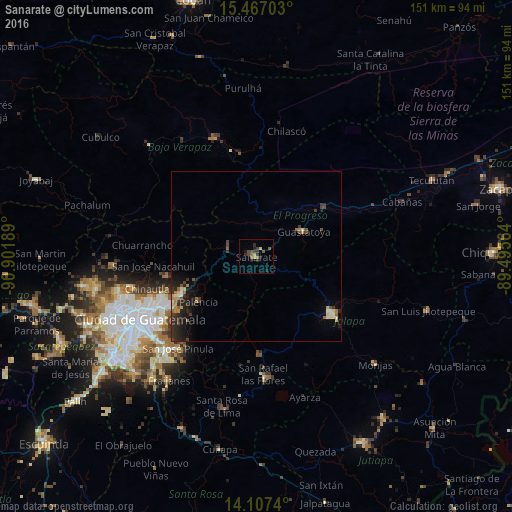
Analysis of Sanarate night lights 2016
Square area 10x10 km:
 0%
0%90-99
0%80-89
1.65%70-79
0.83%60-69
0.41%50-59
3.72%40-49
3.1%30-39
2.89%20-29
4.13%10-19
2.27%0-9
80.99%Square area 50x50 km:
0.06%90-99
0.33%80-89
0.39%70-79
0.3%60-69
0.47%50-59
0.43%40-49
0.53%30-39
0.84%20-29
1.28%10-19
1.97%0-9
93.4%Clear (daylight) street map image can be seen on geolist.org.
Map coordinates:
15° 28' 1.3" North, 90° 54' 6.8" West
14° 47' 17.8" North, 90° 11' 55.5" West
14° 6' 26.6" North, 89° 29' 44.3" West
Some cities around Sanarate sort by population:
• San Pedro Ayampuc
27.4 km =17 mi,  267°
267°
• Jalapa
28.3 km =17.6 mi,  127°
127°
• Palencia
21.7 km =13.5 mi,  231°
231°
• Guastatoya
15.7 km =9.8 mi,  62°
62°
• San Agustín Acasaguastlán
30.7 km =19.1 mi,  54°
54°
• San Jerónimo
30.6 km =19 mi,  351°
351°
• San Antonio La Paz
9.8 km =6.1 mi,  250°
250°
• Mataquescuintla
28.9 km =18 mi,  176°
176°
3590406 (p: 15,843)
Sources (retrieved 2019-11-25):
» Earth at Night: Flat Maps 2012, 2016