San Antonio La Paz night lights from space
Night Light of San Antonio La Paz (El Progreso) from space (Guatemala) Src. Average luminocity for 10x10km area is 0.4669% and for 50x50km: 8.838%.
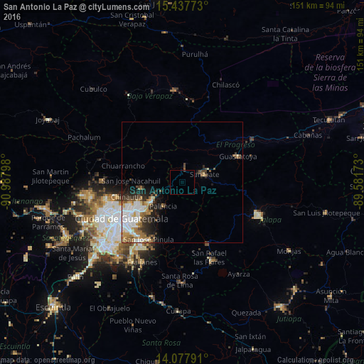
Analysis of San Antonio La Paz night lights 2016
Square area 10x10 km:
 0%
0%90-99
0%80-89
0%70-79
0%60-69
0%50-59
0%40-49
0%30-39
0.41%20-29
0.41%10-19
0%0-9
99.17%Square area 50x50 km:
2.12%90-99
1.95%80-89
0.65%70-79
0.97%60-69
1.5%50-59
0.95%40-49
0.97%30-39
1.34%20-29
1.98%10-19
2.71%0-9
84.86%Clear (daylight) street map image can be seen on geolist.org.
Map coordinates:
15° 26' 15.8" North, 90° 59' 16.7" West
14° 45' 32" North, 90° 17' 5.5" West
14° 4' 40.5" North, 89° 34' 54.2" West
Some cities around San Antonio La Paz sort by population:
• Chinautla
23.9 km =14.9 mi,  254°
254°
• San José Pinula
27.4 km =17 mi,  210°
210°
• San Pedro Ayampuc
18.2 km =11.3 mi,  277°
277°
• Palencia
12.8 km =8 mi,  217°
217°
• Sanarate
9.8 km =6.1 mi,  70°
70°
• Guastatoya
25.5 km =15.8 mi, 65°
• Mataquescuintla
27.7 km =17.2 mi,  157°
157°
• Chuarrancho
25.7 km =16 mi, 284°
3590449 (p: 7,781)
Sources (retrieved 2019-11-25):
» Earth at Night: Flat Maps 2012, 2016