Mataquescuintla night lights from space
Night Light of Mataquescuintla (Jalapa) from space (Guatemala) Src. Average luminocity for 10x10km area is 2.855% and for 50x50km: 3.1424%.
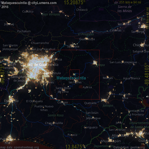
Analysis of Mataquescuintla night lights 2016
Square area 10x10 km:
 0%
0%90-99
0%80-89
0%70-79
0%60-69
0%50-59
1.73%40-49
1.73%30-39
0.87%20-29
0.87%10-19
0%0-9
94.81%Square area 50x50 km:
0.06%90-99
0.34%80-89
0.33%70-79
0.26%60-69
0.63%50-59
0.44%40-49
0.53%30-39
0.77%20-29
1.22%10-19
2.55%0-9
92.87%Clear (daylight) street map image can be seen on geolist.org.
Map coordinates:
15° 12' 31.5" North, 90° 53' 14.3" West
14° 31' 45" North, 90° 11' 3" West
13° 50' 51" North, 89° 28' 51.8" West
Some cities around Mataquescuintla sort by population:
• San José Pinula
24.7 km =15.3 mi,  274°
274°
• Jalapa
24.1 km =15 mi,  60°
60°
• Palencia
24.1 km =15 mi,  309°
309°
• Nueva Santa Rosa
19.2 km =11.9 mi,  211°
211°
• Casillas
13.8 km =8.6 mi, 207°
• San Antonio La Paz
27.7 km =17.2 mi,  337°
337°
• Santa Cruz Naranjo
25.4 km =15.8 mi,  231°
231°
• Santa Rosa de Lima
19.7 km =12.2 mi,  217°
217°
3592635 (p: 7,539)
Sources (retrieved 2019-11-25):
» Earth at Night: Flat Maps 2012, 2016