Palencia night lights from space
Night Light of Palencia (Guatemala) from space (Guatemala) Src. Average luminocity for 10x10km area is 11.7211% and for 50x50km: 19.4659%.
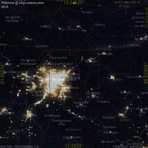
Analysis of Palencia night lights 2016
Square area 10x10 km:
 0.41%
0.41%90-99
0.83%80-89
0%70-79
1.86%60-69
1.24%50-59
1.86%40-49
0.41%30-39
3.72%20-29
7.23%10-19
19.83%0-9
62.6%Square area 50x50 km:
5.27%90-99
4.87%80-89
2.05%70-79
1.74%60-69
2.58%50-59
1.95%40-49
1.96%30-39
2.6%20-29
3.36%10-19
4.75%0-9
68.86%Clear (daylight) street map image can be seen on geolist.org.
Map coordinates:
15° 20' 46.6" North, 91° 3' 37.2" West
14° 40' 1.7" North, 90° 21' 26" West
13° 59' 9.2" North, 89° 39' 14.7" West
Some cities around Palencia sort by population:
• Guatemala City
17 km =10.6 mi,  260°
260°
• Chinautla
15.8 km =9.8 mi,  284°
284°
• Santa Catarina Pinula
18.7 km =11.6 mi,  234°
234°
• San José Pinula
14.7 km =9.1 mi,  203°
203°
• San Pedro Ayampuc
16.2 km =10.1 mi,  320°
320°
• Sanarate
21.7 km =13.5 mi,  51°
51°
• San Antonio La Paz
12.8 km =8 mi,  37°
37°
• Chuarrancho
23.9 km =14.9 mi,  314°
314°
3591851 (p: 18,574)
Sources (retrieved 2019-11-25):
» Earth at Night: Flat Maps 2012, 2016