San Pedro Ayampuc night lights from space
Night Light of San Pedro Ayampuc (Guatemala) from space (Guatemala) Src. Average luminocity for 10x10km area is 3.9835% and for 50x50km: 18.3213%.

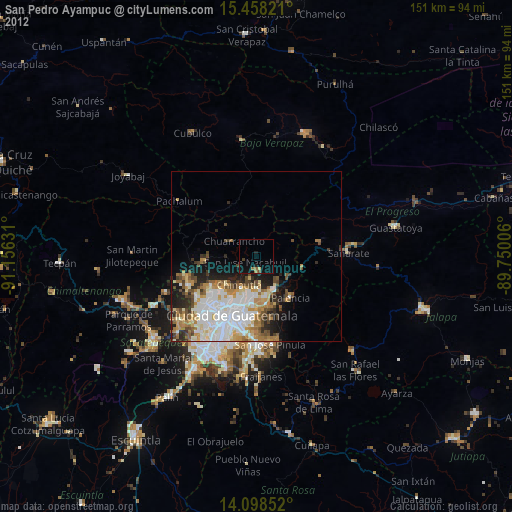
Analysis of San Pedro Ayampuc night lights 2016
Square area 10x10 km:
 0%
0%90-99
0%80-89
0%70-79
0%60-69
0.83%50-59
1.03%40-49
1.45%30-39
1.24%20-29
1.24%10-19
2.48%0-9
91.74%Square area 50x50 km:
5.1%90-99
4.32%80-89
1.69%70-79
1.81%60-69
2.82%50-59
1.85%40-49
1.86%30-39
2.3%20-29
3.43%10-19
4.26%0-9
70.55%Clear (daylight) street map image can be seen on geolist.org.
Map coordinates:
15° 27' 29.6" North, 91° 9' 22.7" West
14° 46' 45.9" North, 90° 27' 11.4" West
14° 5' 54.7" North, 89° 45' 0.2" West
Some cities around San Pedro Ayampuc sort by population:
• Guatemala City
16.7 km =10.4 mi,  202°
202°
• Mixco
23.4 km =14.5 mi,  225°
225°
• San Juan Sacatepéquez
21.6 km =13.4 mi,  251°
251°
• Chinautla
9.9 km =6.2 mi,  210°
210°
• Palencia
16.2 km =10.1 mi,  140°
140°
• San Raimundo
15.3 km =9.5 mi,  263°
263°
• San Antonio La Paz
18.2 km =11.3 mi,  97°
97°
• Chuarrancho
8 km =5 mi,  302°
302°
3589646 (p: 46,803)
Sources (retrieved 2019-11-25):
» Earth at Night: Flat Maps 2012, 2016