San Miguel Sigüilá night lights from space
Night Light of San Miguel Sigüilá (Quetzaltenango) from space (Guatemala) Src. Average luminocity for 10x10km area is 25.6426% and for 50x50km: 9.7257%.
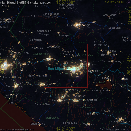
Analysis of San Miguel Sigüilá night lights 2016
Square area 10x10 km:
 1.03%
1.03%90-99
2.69%80-89
3.51%70-79
1.65%60-69
4.34%50-59
5.58%40-49
4.13%30-39
8.26%20-29
8.47%10-19
25%0-9
35.33%Square area 50x50 km:
0.48%90-99
1.41%80-89
1.48%70-79
1.06%60-69
1.5%50-59
0.95%40-49
1.74%30-39
2.62%20-29
3.18%10-19
7.54%0-9
78.03%Clear (daylight) street map image can be seen on geolist.org.
Map coordinates:
15° 34' 26" North, 92° 19' 3.7" West
14° 53' 43.7" North, 91° 36' 52.5" West
14° 12' 53.7" North, 90° 54' 41.2" West
Some cities around San Miguel Sigüilá sort by population:
• Quetzaltenango
12.4 km =7.7 mi,  123°
123°
• Ostuncalco
3 km =1.9 mi,  193°
193°
• La Esperanza
6.3 km =3.9 mi,  114°
114°
• San Andrés Xecul
14.2 km =8.8 mi,  85°
85°
• Salcajá
17 km =10.6 mi,  95°
95°
• Almolonga
15.6 km =9.7 mi, 124°
• Concepción Chiquirichapa
4.6 km =2.9 mi, 192°
• San Carlos Sija
12.1 km =7.5 mi,  35°
35°
3589706 (p: 7,551)
Sources (retrieved 2019-11-25):
» Earth at Night: Flat Maps 2012, 2016