Chuarrancho night lights from space
Night Light of Chuarrancho (Guatemala) from space (Guatemala) Src. Average luminocity for 10x10km area is 0.1529% and for 50x50km: 15.3991%.
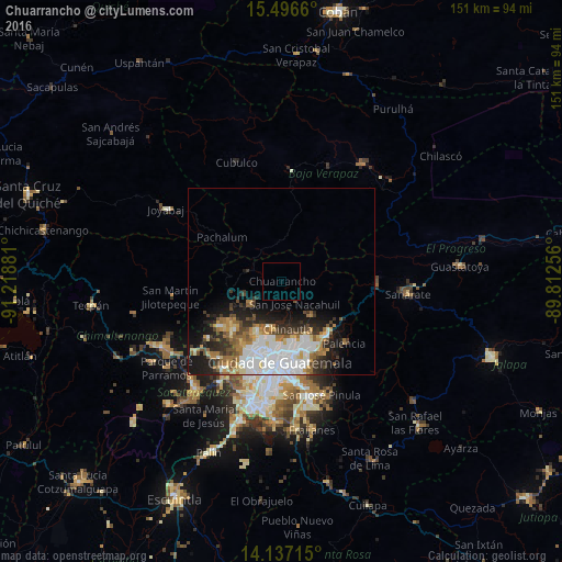
Analysis of Chuarrancho night lights 2016
Square area 10x10 km:
 0%
0%90-99
0%80-89
0%70-79
0%60-69
0%50-59
0%40-49
0%30-39
0%20-29
0%10-19
0%0-9
100%Square area 50x50 km:
4.15%90-99
3.28%80-89
1.38%70-79
1.42%60-69
2.34%50-59
1.6%40-49
1.56%30-39
2.09%20-29
3.5%10-19
5.8%0-9
72.88%Clear (daylight) street map image can be seen on geolist.org.
Map coordinates:
15° 29' 47.8" North, 91° 13' 7.7" West
14° 49' 4.6" North, 90° 30' 56.4" West
14° 8' 13.7" North, 89° 48' 45.2" West
Some cities around Chuarrancho sort by population:
• Guatemala City
19.7 km =12.2 mi,  179°
179°
• Mixco
23 km =14.3 mi,  205°
205°
• San Juan Sacatepéquez
17.7 km =11 mi,  231°
231°
• Chinautla
12.9 km =8 mi,  172°
172°
• San Pedro Ayampuc
8 km =5 mi,  122°
122°
• Palencia
23.9 km =14.9 mi,  134°
134°
• San Pedro Sacatepéquez
20 km =12.4 mi,  222°
222°
• San Raimundo
10.4 km =6.5 mi,  235°
235°
3598277 (p: 7,149)
Sources (retrieved 2019-11-25):
» Earth at Night: Flat Maps 2012, 2016