Pajapita night lights from space
Night Light of Pajapita (San Marcos) from space (Guatemala) Src. Average luminocity for 10x10km area is 3.3017% and for 50x50km: 6.5365%.
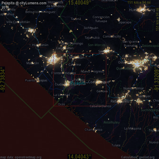
Analysis of Pajapita night lights 2016
Square area 10x10 km:
 0%
0%90-99
0%80-89
0%70-79
0%60-69
0.83%50-59
0.83%40-49
0.83%30-39
1.45%20-29
2.27%10-19
2.69%0-9
91.12%Square area 50x50 km:
0.31%90-99
0.8%80-89
0.79%70-79
0.83%60-69
0.88%50-59
0.78%40-49
1.49%30-39
1.71%20-29
2.09%10-19
3.38%0-9
86.95%Clear (daylight) street map image can be seen on geolist.org.
Map coordinates:
15° 24' 1.8" North, 92° 44' 18" West
14° 43' 17.5" North, 92° 2' 6.8" West
14° 2' 25.5" North, 91° 19' 55.5" West
Some cities around Pajapita sort by population:
• Coatepeque
18.5 km =11.5 mi,  96°
96°
• Malacatán
21.2 km =13.2 mi,  353°
353°
• Ciudad Hidalgo, MX
13.3 km =8.3 mi,  250°
250°
• San Pablo
23.7 km =14.7 mi,  8°
8°
• Flores Costa Cuca
21 km =13 mi,  118°
118°
• Ciudad Tecún Umán
12.3 km =7.6 mi, 246°
• Nuevo Progreso
14.7 km =9.1 mi,  57°
57°
• El Tumbador
19.2 km =11.9 mi,  34°
34°
3591885 (p: 8,164)
Sources (retrieved 2019-11-25):
» Earth at Night: Flat Maps 2012, 2016