San Pablo night lights from space
Night Light of San Pablo (San Marcos) from space (Guatemala) Src. Average luminocity for 10x10km area is 6.7665% and for 50x50km: 5.8771%.
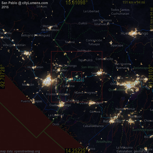
Analysis of San Pablo night lights 2016
Square area 10x10 km:
 0%
0%90-99
0.41%80-89
0.21%70-79
1.03%60-69
0.62%50-59
1.86%40-49
1.24%30-39
3.51%20-29
2.48%10-19
1.03%0-9
87.6%Square area 50x50 km:
0.12%90-99
0.45%80-89
0.54%70-79
0.68%60-69
0.69%50-59
0.79%40-49
1.62%30-39
1.94%20-29
1.97%10-19
4.03%0-9
87.17%Clear (daylight) street map image can be seen on geolist.org.
Map coordinates:
15° 36' 39.5" North, 92° 42' 26.2" West
14° 55' 57.7" North, 92° 0' 14.9" West
14° 15' 8.1" North, 91° 18' 3.7" West
Some cities around San Pablo sort by population:
• San Marcos
22.8 km =14.2 mi,  81°
81°
• Cacahoatán, MX
18.4 km =11.4 mi,  291°
291°
• Malacatán
6.2 km =3.9 mi,  247°
247°
• San Cristóbal Cucho
24.1 km =15 mi,  97°
97°
• Pajapita
23.7 km =14.7 mi,  188°
188°
• Nuevo Progreso
18.1 km =11.2 mi,  149°
149°
• El Tumbador
10.7 km =6.6 mi,  135°
135°
• Tuxtla Chico, MX
17.5 km =10.9 mi,  272°
272°
3589677 (p: 13,668)
Sources (retrieved 2019-11-25):
» Earth at Night: Flat Maps 2012, 2016