Malacatán night lights from space
Night Light of Malacatán (San Marcos) from space (Guatemala) Src. Average luminocity for 10x10km area is 13.1012% and for 50x50km: 7.9455%.
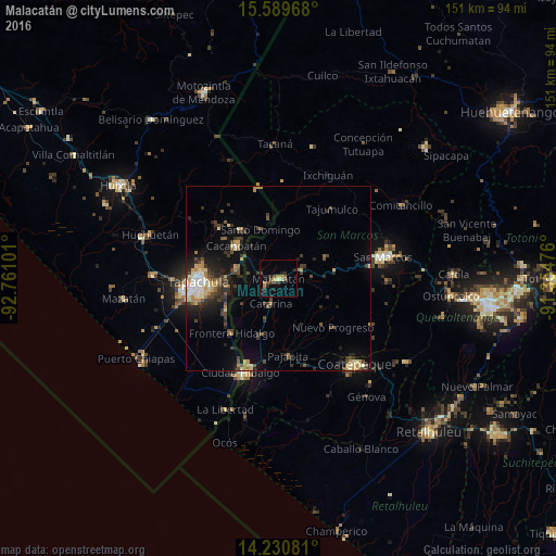
Analysis of Malacatán night lights 2016
Square area 10x10 km:
 0%
0%90-99
1.65%80-89
0.83%70-79
2.69%60-69
1.45%50-59
2.07%40-49
2.07%30-39
3.72%20-29
5.99%10-19
3.31%0-9
76.24%Square area 50x50 km:
0.55%90-99
1.07%80-89
0.95%70-79
1.03%60-69
0.88%50-59
0.9%40-49
1.74%30-39
2.02%20-29
2.5%10-19
4.29%0-9
84.09%Clear (daylight) street map image can be seen on geolist.org.
Map coordinates:
15° 35' 22.8" North, 92° 45' 39.6" West
14° 54' 40.8" North, 92° 3' 28.4" West
14° 13' 50.9" North, 91° 21' 17.1" West
Some cities around Malacatán sort by population:
• Tapachula, MX
21.5 km =13.4 mi,  267°
267°
• Cacahoatán, MX
14.5 km =9 mi,  308°
308°
• San Pablo
6.2 km =3.9 mi,  67°
67°
• Pajapita
21.2 km =13.2 mi,  173°
173°
• Nuevo Progreso
20 km =12.4 mi,  131°
131°
• El Tumbador
14.3 km =8.9 mi,  111°
111°
• Tuxtla Chico, MX
12.2 km =7.6 mi,  284°
284°
• Vida Mejor I, MX
27.2 km =16.9 mi,  260°
260°
3592753 (p: 14,923)
Sources (retrieved 2019-11-25):
» Earth at Night: Flat Maps 2012, 2016