Ciudad Tecún Umán night lights from space
Night Light of Ciudad Tecún Umán (San Marcos) from space (Guatemala) Src. Average luminocity for 10x10km area is 24.2934% and for 50x50km: 5.4594%.
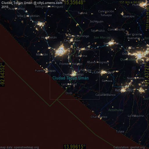
Analysis of Ciudad Tecún Umán night lights 2016
Square area 10x10 km:
 0%
0%90-99
2.89%80-89
6.61%70-79
3.51%60-69
5.99%50-59
3.1%40-49
4.34%30-39
0.62%20-29
2.27%10-19
17.98%0-9
52.69%Square area 50x50 km:
0.43%90-99
0.69%80-89
0.82%70-79
0.55%60-69
0.77%50-59
0.66%40-49
0.98%30-39
1.22%20-29
1.56%10-19
3.32%0-9
89%Clear (daylight) street map image can be seen on geolist.org.
Map coordinates:
15° 21' 23.3" North, 92° 50' 36.7" West
14° 40' 38.5" North, 92° 8' 25.4" West
13° 59' 46.1" North, 91° 26' 14.2" West
Some cities around Ciudad Tecún Umán sort by population:
• Tapachula, MX
28.2 km =17.5 mi,  333°
333°
• Malacatán
27.5 km =17.1 mi,  18°
18°
• Brisas Barra de Suchiate, MX
18.1 km =11.2 mi,  209°
209°
• Ocós
19.5 km =12.1 mi,  196°
196°
• Pajapita
12.3 km =7.6 mi,  66°
66°
• Nuevo Progreso
26.9 km =16.7 mi,  61°
61°
• Tuxtla Chico, MX
29.3 km =18.2 mi,  354°
354°
• Vida Mejor I, MX
28 km =17.4 mi,  319°
319°
3598129 (p: 11,432)
Sources (retrieved 2019-11-25):
» Earth at Night: Flat Maps 2012, 2016