Nuevo Progreso night lights from space
Night Light of Nuevo Progreso (San Marcos) from space (Guatemala) Src. Average luminocity for 10x10km area is 1.5103% and for 50x50km: 5.124%.
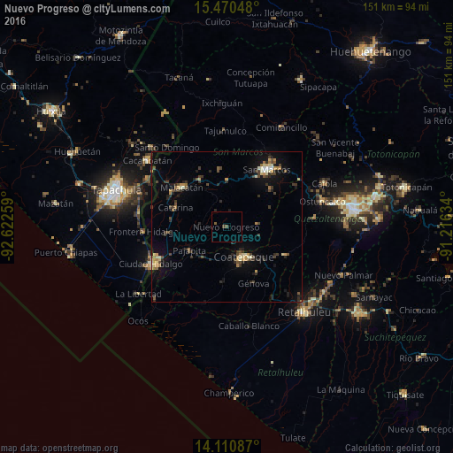
Analysis of Nuevo Progreso night lights 2016
Square area 10x10 km:
 0%
0%90-99
0%80-89
0%70-79
0%60-69
0%50-59
0.83%40-49
1.24%30-39
0.41%20-29
0%10-19
0%0-9
97.52%Square area 50x50 km:
0.11%90-99
0.56%80-89
0.64%70-79
0.65%60-69
0.58%50-59
0.55%40-49
1.05%30-39
1.32%20-29
1.51%10-19
3.22%0-9
89.8%Clear (daylight) street map image can be seen on geolist.org.
Map coordinates:
15° 28' 13.7" North, 92° 37' 21.3" West
14° 47' 30.3" North, 91° 55' 10.1" West
14° 6' 39.1" North, 91° 12' 58.8" West
Some cities around Nuevo Progreso sort by population:
• Coatepeque
11.4 km =7.1 mi,  148°
148°
• Malacatán
20 km =12.4 mi,  311°
311°
• San Pablo
18.1 km =11.2 mi,  329°
329°
• El Quetzal
11.3 km =7 mi,  103°
103°
• Flores Costa Cuca
18.7 km =11.6 mi,  161°
161°
• San Cristóbal Cucho
19.5 km =12.1 mi,  49°
49°
• Pajapita
14.7 km =9.1 mi,  237°
237°
• El Tumbador
8.2 km =5.1 mi,  348°
348°
3592108 (p: 8,113)
Sources (retrieved 2019-11-25):
» Earth at Night: Flat Maps 2012, 2016