Flores Costa Cuca night lights from space
Night Light of Flores Costa Cuca (Quetzaltenango) from space (Guatemala) Src. Average luminocity for 10x10km area is 3.9913% and for 50x50km: 3.1286%.
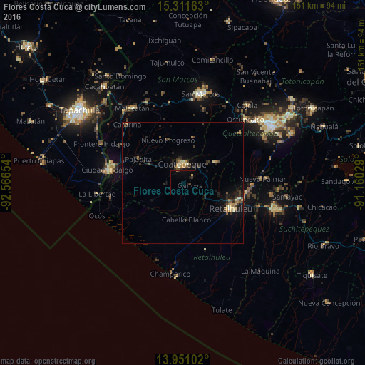
Analysis of Flores Costa Cuca night lights 2016
Square area 10x10 km:
 0%
0%90-99
0%80-89
0.22%70-79
0.65%60-69
0.43%50-59
0%40-49
0.65%30-39
1.3%20-29
1.08%10-19
1.52%0-9
94.16%Square area 50x50 km:
0.02%90-99
0.33%80-89
0.36%70-79
0.34%60-69
0.51%50-59
0.32%40-49
0.74%30-39
0.84%20-29
1.11%10-19
2.11%0-9
93.32%Clear (daylight) street map image can be seen on geolist.org.
Map coordinates:
15° 18' 41.9" North, 92° 33' 59.5" West
14° 37' 56.6" North, 91° 51' 48.3" West
13° 57' 3.7" North, 91° 9' 37" West
Some cities around Flores Costa Cuca sort by population:
• Coatepeque
8 km =5 mi,  359°
359°
• Retalhuleu
22.7 km =14.1 mi,  118°
118°
• Nuevo San Carlos
18.8 km =11.7 mi,  103°
103°
• Colomba
16.4 km =10.2 mi,  59°
59°
• El Quetzal
15.9 km =9.9 mi,  18°
18°
• Pajapita
21 km =13 mi,  298°
298°
• Nuevo Progreso
18.7 km =11.6 mi,  341°
341°
• El Asintal
15.2 km =9.4 mi,  105°
105°
3595721 (p: 11,984)
Sources (retrieved 2019-11-25):
» Earth at Night: Flat Maps 2012, 2016