Ciudad Hidalgo night lights from space
Night Light of Ciudad Hidalgo (Chiapas) from space (Mexico) Src. Average luminocity for 10x10km area is 24.2831% and for 50x50km: 5.7361%.
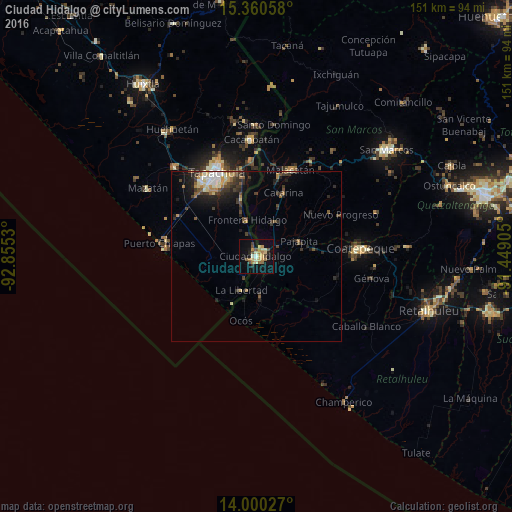
Analysis of Ciudad Hidalgo night lights 2016
Square area 10x10 km:
 0%
0%90-99
2.89%80-89
6.61%70-79
3.51%60-69
5.99%50-59
3.1%40-49
3.93%30-39
0.62%20-29
2.27%10-19
17.98%0-9
53.1%Square area 50x50 km:
0.45%90-99
0.8%80-89
0.83%70-79
0.57%60-69
0.81%50-59
0.73%40-49
1.04%30-39
1.25%20-29
1.59%10-19
3.37%0-9
88.56%Clear (daylight) street map image can be seen on geolist.org.
Map coordinates:
15° 21' 38.1" North, 92° 51' 19.1" West
14° 40' 53.3" North, 92° 9' 7.8" West
14° 0' 1" North, 91° 26' 56.6" West
Some cities around Ciudad Hidalgo sort by population:
• Tapachula
27.2 km =16.9 mi,  335°
335°
• Malacatán, GT
27.5 km =17.1 mi,  21°
21°
• Brisas Barra de Suchiate
17.9 km =11.1 mi,  205°
205°
• Ocós, GT
19.6 km =12.2 mi,  192°
192°
• Pajapita, GT
13.3 km =8.3 mi,  70°
70°
• Nuevo Progreso, GT
27.9 km =17.3 mi,  63°
63°
• Tuxtla Chico
28.7 km =17.8 mi,  356°
356°
• Vida Mejor I
26.8 km =16.7 mi,  321°
321°
3530595 (p: 14,606)
Sources (retrieved 2019-11-25):
» Earth at Night: Flat Maps 2012, 2016