El Quetzal night lights from space
Night Light of El Quetzal (San Marcos) from space (Guatemala) Src. Average luminocity for 10x10km area is 2.3595% and for 50x50km: 5.7778%.
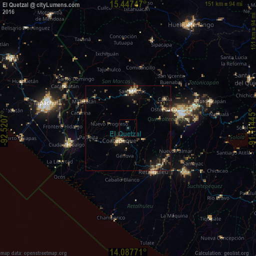
Analysis of El Quetzal night lights 2016
Square area 10x10 km:
 0%
0%90-99
0%80-89
0%70-79
0.21%60-69
0.62%50-59
0%40-49
0.62%30-39
1.03%20-29
0%10-19
0.21%0-9
97.31%Square area 50x50 km:
0.13%90-99
0.67%80-89
0.61%70-79
0.66%60-69
0.76%50-59
0.7%40-49
1.39%30-39
1.58%20-29
1.69%10-19
4.8%0-9
87%Clear (daylight) street map image can be seen on geolist.org.
Map coordinates:
15° 26' 50.9" North, 92° 31' 14.5" West
14° 46' 7.1" North, 91° 49' 3.3" West
14° 5' 15.8" North, 91° 6' 52" West
Some cities around El Quetzal sort by population:
• Coatepeque
8.8 km =5.5 mi,  214°
214°
• San Marcos
21.9 km =13.6 mi,  6°
6°
• Colomba
11.5 km =7.1 mi,  126°
126°
• Flores Costa Cuca
15.9 km =9.9 mi,  198°
198°
• San Cristóbal Cucho
15.7 km =9.8 mi, 14°
• Nuevo Progreso
11.3 km =7 mi,  283°
283°
• El Tumbador
16.4 km =10.2 mi,  310°
310°
• El Asintal
21.5 km =13.4 mi,  153°
153°
3596389 (p: 12,122)
Sources (retrieved 2019-11-25):
» Earth at Night: Flat Maps 2012, 2016