San Cristóbal Cucho night lights from space
Night Light of San Cristóbal Cucho (San Marcos) from space (Guatemala) Src. Average luminocity for 10x10km area is 9.3636% and for 50x50km: 5.3442%.
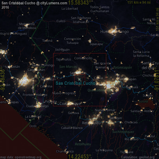
Analysis of San Cristóbal Cucho night lights 2016
Square area 10x10 km:
 0%
0%90-99
0.41%80-89
0.83%70-79
0.41%60-69
0.83%50-59
0.62%40-49
3.1%30-39
3.51%20-29
2.07%10-19
16.74%0-9
71.49%Square area 50x50 km:
0.15%90-99
0.65%80-89
0.66%70-79
0.62%60-69
0.74%50-59
0.57%40-49
1.07%30-39
1.55%20-29
1.71%10-19
4.34%0-9
87.94%Clear (daylight) street map image can be seen on geolist.org.
Map coordinates:
15° 35' 0.3" North, 92° 29' 3.7" West
14° 54' 18.2" North, 91° 46' 52.4" West
14° 13' 28.3" North, 91° 4' 41.2" West
Some cities around San Cristóbal Cucho sort by population:
• San Pedro Sacatepéquez
7.3 km =4.5 mi,  16°
16°
• Ostuncalco
17.6 km =10.9 mi,  103°
103°
• San Marcos
6.7 km =4.2 mi,  347°
347°
• El Quetzal
15.7 km =9.8 mi,  194°
194°
• Nuevo Progreso
19.5 km =12.1 mi,  229°
229°
• Concepción Chiquirichapa
17.8 km =11.1 mi,  108°
108°
• El Tumbador
17.1 km =10.6 mi,  254°
254°
• San Miguel Sigüilá
17.9 km =11.1 mi,  93°
93°
3590323 (p: 9,152)
Sources (retrieved 2019-11-25):
» Earth at Night: Flat Maps 2012, 2016