La Democracia night lights from space
Night Light of La Democracia (Escuintla) from space (Guatemala) Src. Average luminocity for 10x10km area is 3.2792% and for 50x50km: 3.779%.
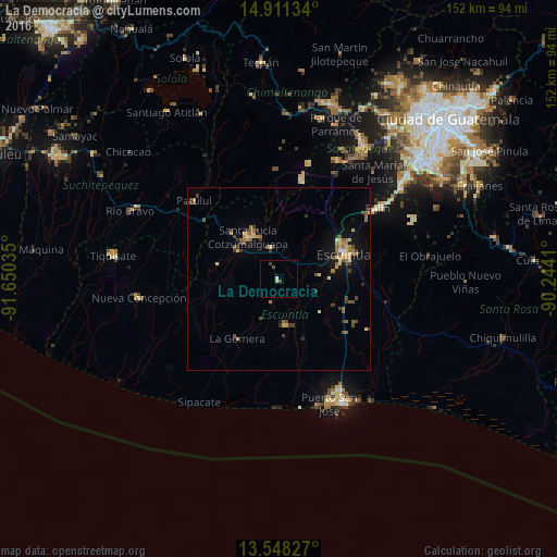
Analysis of La Democracia night lights 2016
Square area 10x10 km:
 0%
0%90-99
0.87%80-89
0.87%70-79
0%60-69
0%50-59
0%40-49
1.73%30-39
0.87%20-29
0%10-19
0.87%0-9
94.81%Square area 50x50 km:
0.06%90-99
0.3%80-89
0.56%70-79
0.53%60-69
0.69%50-59
0.77%40-49
0.74%30-39
0.75%20-29
0.43%10-19
2.05%0-9
93.12%Clear (daylight) street map image can be seen on geolist.org.
Map coordinates:
14° 54' 40.8" North, 91° 39' 1.3" West
14° 13' 51" North, 90° 56' 50" West
13° 32' 53.8" North, 90° 14' 38.8" West
Some cities around La Democracia sort by population:
• Escuintla
19.3 km =12 mi,  64°
64°
• Santa Lucía Cotzumalguapa
14.2 km =8.8 mi,  324°
324°
• Palín
33.1 km =20.6 mi,  54°
54°
• La Gomera
20.1 km =12.5 mi,  214°
214°
• Alotenango
31.6 km =19.6 mi,  28°
28°
• Patulul
31.4 km =19.5 mi,  312°
312°
• Masagua
11.1 km =6.9 mi,  106°
106°
• Yepocapa
30.2 km =18.8 mi,  358°
358°
3594753 (p: 5,479)
Sources (retrieved 2019-11-25):
» Earth at Night: Flat Maps 2012, 2016