Masagua night lights from space
Night Light of Masagua (Escuintla) from space (Guatemala) Src. Average luminocity for 10x10km area is 3.6082% and for 50x50km: 4.4035%.
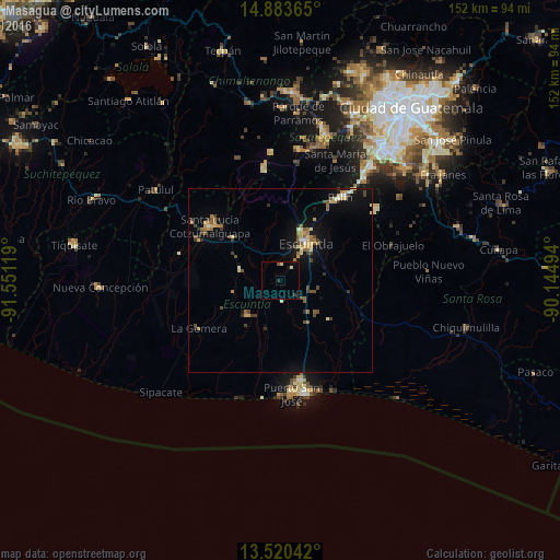
Analysis of Masagua night lights 2016
Square area 10x10 km:
 0%
0%90-99
0.43%80-89
1.3%70-79
0%60-69
0%50-59
0.87%40-49
0%30-39
0.87%20-29
0.87%10-19
0.87%0-9
94.81%Square area 50x50 km:
0.12%90-99
0.41%80-89
0.75%70-79
0.6%60-69
0.69%50-59
0.73%40-49
0.76%30-39
0.76%20-29
0.48%10-19
2.96%0-9
91.73%Clear (daylight) street map image can be seen on geolist.org.
Map coordinates:
14° 53' 1.1" North, 91° 33' 4.3" West
14° 12' 11" North, 90° 50' 53" West
13° 31' 13.5" North, 90° 8' 41.8" West
Some cities around Masagua sort by population:
• Escuintla
13.2 km =8.2 mi,  30°
30°
• Santa Lucía Cotzumalguapa
23.9 km =14.9 mi,  307°
307°
• Palín
27.6 km =17.1 mi,  36°
36°
• La Gomera
25.9 km =16.1 mi,  238°
238°
• Puerto San José
30.8 km =19.1 mi,  174°
174°
• Alotenango
31.1 km =19.3 mi,  8°
8°
• San Vicente Pacaya
32.8 km =20.4 mi, 44°
• La Democracia
11.1 km =6.9 mi,  286°
286°
3592642 (p: 10,045)
Sources (retrieved 2019-11-25):
» Earth at Night: Flat Maps 2012, 2016