Joyabaj night lights from space
Night Light of Joyabaj (Quiché) from space (Guatemala) Src. Average luminocity for 10x10km area is 3.6033% and for 50x50km: 0.4848%.
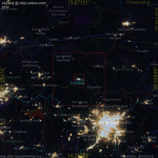
Analysis of Joyabaj night lights 2016
Square area 10x10 km:
 0%
0%90-99
1.03%80-89
0.62%70-79
0%60-69
0%50-59
0.83%40-49
1.03%30-39
0.62%20-29
2.48%10-19
0%0-9
93.39%Square area 50x50 km:
0%90-99
0.04%80-89
0.02%70-79
0.04%60-69
0.04%50-59
0.1%40-49
0.13%30-39
0.23%20-29
0.29%10-19
0.13%0-9
98.97%Clear (daylight) street map image can be seen on geolist.org.
Map coordinates:
15° 40' 16.4" North, 91° 30' 17.1" West
14° 59' 35.2" North, 90° 48' 5.8" West
14° 18' 46.3" North, 90° 5' 54.6" West
Some cities around Joyabaj sort by population:
• Chichicastenango
33.7 km =20.9 mi,  260°
260°
• Tecpán Guatemala
32.9 km =20.4 mi,  218°
218°
• Comalapa
29.5 km =18.3 mi,  198°
198°
• San Martín Jilotepeque
23.7 km =14.7 mi,  177°
177°
• Cubulco
22.3 km =13.9 mi,  56°
56°
• Zacualpa
9 km =5.6 mi,  294°
294°
• San Raimundo
33.7 km =20.9 mi,  138°
138°
• San José Poaquil
22.8 km =14.2 mi,  211°
211°
3595148 (p: 13,164)
Sources (retrieved 2019-11-25):
» Earth at Night: Flat Maps 2012, 2016