San Raimundo night lights from space
Night Light of San Raimundo (Guatemala) from space (Guatemala) Src. Average luminocity for 10x10km area is 16.719% and for 50x50km: 22.8395%.
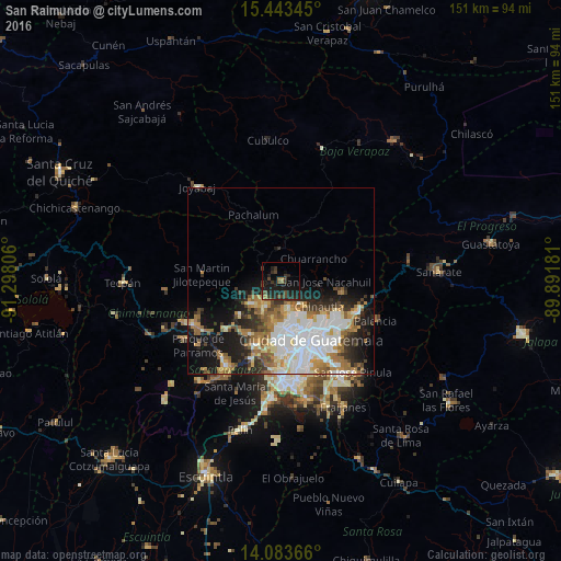
Analysis of San Raimundo night lights 2016
Square area 10x10 km:
 0%
0%90-99
0%80-89
0.21%70-79
0.83%60-69
2.69%50-59
1.86%40-49
6.61%30-39
6.82%20-29
13.22%10-19
23.76%0-9
44.01%Square area 50x50 km:
5.49%90-99
5.03%80-89
2.17%70-79
2.51%60-69
3.86%50-59
2.5%40-49
2.34%30-39
2.66%20-29
4.64%10-19
9.63%0-9
59.16%Clear (daylight) street map image can be seen on geolist.org.
Map coordinates:
15° 26' 36.4" North, 91° 17' 53" West
14° 45' 52.6" North, 90° 35' 41.7" West
14° 5' 1.2" North, 89° 53' 30.5" West
Some cities around San Raimundo sort by population:
• Guatemala City
16.3 km =10.1 mi,  147°
147°
• Mixco
14.9 km =9.3 mi,  185°
185°
• San Juan Sacatepéquez
7.3 km =4.5 mi,  226°
226°
• Chinautla
12.3 km =7.6 mi,  123°
123°
• San Pedro Ayampuc
15.3 km =9.5 mi,  83°
83°
• San Pedro Sacatepéquez
10.1 km =6.3 mi,  210°
210°
• Santo Domingo Xenacoj
14.7 km =9.1 mi, 230°
• Chuarrancho
10.4 km =6.5 mi,  55°
55°
3589569 (p: 8,689)
Sources (retrieved 2019-11-25):
» Earth at Night: Flat Maps 2012, 2016