San José Poaquil night lights from space
Night Light of San José Poaquil (Chimaltenango) from space (Guatemala) Src. Average luminocity for 10x10km area is 0.0207% and for 50x50km: 3.8843%.
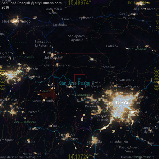
Analysis of San José Poaquil night lights 2016
Square area 10x10 km:
 0%
0%90-99
0%80-89
0%70-79
0%60-69
0%50-59
0%40-49
0%30-39
0%20-29
0%10-19
0%0-9
100%Square area 50x50 km:
0.04%90-99
0.12%80-89
0.53%70-79
0.47%60-69
0.82%50-59
0.64%40-49
0.84%30-39
0.79%20-29
1.55%10-19
4.33%0-9
89.86%Clear (daylight) street map image can be seen on geolist.org.
Map coordinates:
15° 29' 48.3" North, 91° 36' 56.2" West
14° 49' 5.1" North, 90° 54' 44.9" West
14° 8' 14.2" North, 90° 12' 33.7" West
Some cities around San José Poaquil sort by population:
• Chimaltenango
20.1 km =12.5 mi,  150°
150°
• Tecpán Guatemala
10.6 km =6.6 mi,  233°
233°
• Comalapa
9 km =5.6 mi,  162°
162°
• Patzún
18.7 km =11.6 mi,  215°
215°
• Patzicía
20.8 km =12.9 mi,  184°
184°
• San Martín Jilotepeque
13.6 km =8.5 mi,  108°
108°
• Zaragoza
18.9 km =11.7 mi,  172°
172°
• Santa Cruz Balanyá
14.8 km =9.2 mi, 182°
3589975 (p: 5,987)
Sources (retrieved 2019-11-25):
» Earth at Night: Flat Maps 2012, 2016