San Martín Jilotepeque night lights from space
Night Light of San Martín Jilotepeque (Chimaltenango) from space (Guatemala) Src. Average luminocity for 10x10km area is 0.9091% and for 50x50km: 11.7177%.
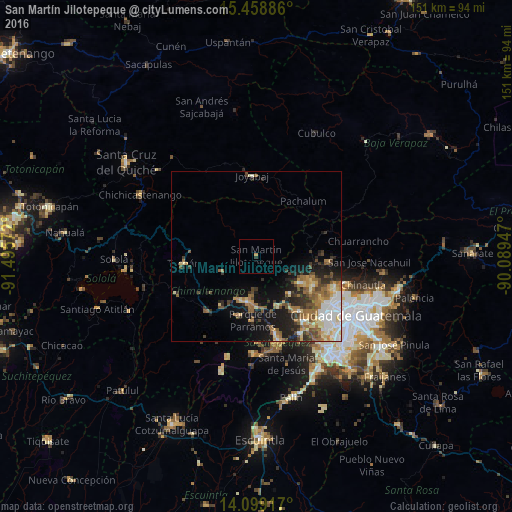
Analysis of San Martín Jilotepeque night lights 2016
Square area 10x10 km:
 0%
0%90-99
0%80-89
0%70-79
0.83%60-69
0%50-59
0%40-49
0%30-39
0.83%20-29
0%10-19
0%0-9
98.35%Square area 50x50 km:
1.55%90-99
1.84%80-89
1.56%70-79
1.4%60-69
2.43%50-59
1.8%40-49
1.82%30-39
1.75%20-29
2.67%10-19
6.66%0-9
76.52%Clear (daylight) street map image can be seen on geolist.org.
Map coordinates:
15° 27' 31.9" North, 91° 29' 44.6" West
14° 46' 48.3" North, 90° 47' 33.3" West
14° 5' 57" North, 90° 5' 22.1" West
Some cities around San Martín Jilotepeque sort by population:
• San Juan Sacatepéquez
17.3 km =10.7 mi,  113°
113°
• Chimaltenango
13.5 km =8.4 mi,  192°
192°
• Sumpango
16.2 km =10.1 mi,  157°
157°
• Comalapa
11.1 km =6.9 mi,  246°
246°
• El Tejar
14.8 km =9.2 mi,  179°
179°
• Santo Domingo Xenacoj
14.9 km =9.3 mi,  138°
138°
• Santa Cruz Balanyá
17.2 km =10.7 mi,  232°
232°
• San José Poaquil
13.6 km =8.5 mi,  288°
288°
3589780 (p: 9,846)
Sources (retrieved 2019-11-25):
» Earth at Night: Flat Maps 2012, 2016