Pallíni night lights from space
Night Light of Pallíni (Attica) from space (Greece) Src. Average luminocity for 10x10km area is 84.3912% and for 50x50km: 43.254%.
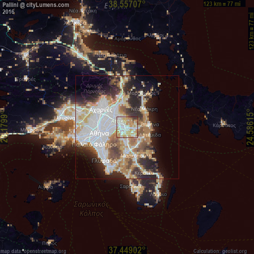
Analysis of Pallíni night lights 2016
Square area 10x10 km:
 20.78%
90-99
27.76%80-89
11.85%70-79
25.32%60-69
7.63%50-59
2.27%40-49
1.14%30-39
3.08%20-29
0.16%10-19
0%0-9
0%Square area 50x50 km:
12.47%90-99
9.96%80-89
4.35%70-79
5.83%60-69
6.11%50-59
4.18%40-49
3.86%30-39
4.47%20-29
8.39%10-19
8.35%0-9
32.03%Clear (daylight) street map image can be seen on geolist.org.
Map coordinates:
38° 33' 25.5" North, 23° 10' 47.6" East
38° 0' 18.5" North, 23° 52' 58.9" East
37° 26' 56.5" North, 24° 35' 10.1" East
Some cities around Pallíni sort by population:
• Agía Paraskeví
4.5 km =2.8 mi,  286°
286°
• Vrilissia
5.7 km =3.5 mi,  304°
304°
• Gérakas
3 km =1.9 mi,  311°
311°
• Melíssia
6.6 km =4.1 mi,  318°
318°
• Paianía
6.1 km =3.8 mi,  204°
204°
• Spáta
5.6 km =3.5 mi,  149°
149°
• Néa Pentéli
6.5 km =4 mi,  341°
341°
• Leondárion
3.2 km =2 mi,  230°
230°
255971 (p: 14,808)
Sources (retrieved 2019-11-25):
» Earth at Night: Flat Maps 2012, 2016