Leondárion night lights from space
Night Light of Leondárion (Attica) from space (Greece) Src. Average luminocity for 10x10km area is 85.4286% and for 50x50km: 45.2179%.
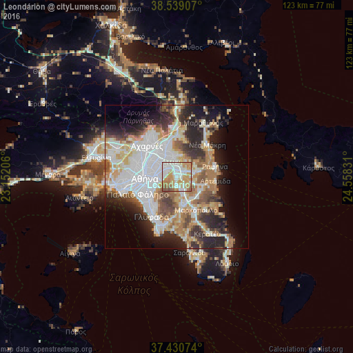
Analysis of Leondárion night lights 2016
Square area 10x10 km:
 25.49%
90-99
25%80-89
9.9%70-79
23.54%60-69
8.93%50-59
5.84%40-49
1.3%30-39
0%20-29
0%10-19
0%0-9
0%Square area 50x50 km:
12.82%90-99
10.32%80-89
4.69%70-79
6.04%60-69
6.52%50-59
4.33%40-49
4.19%30-39
4.43%20-29
9.37%10-19
9.21%0-9
28.09%Clear (daylight) street map image can be seen on geolist.org.
Map coordinates:
38° 32' 20.7" North, 23° 9' 7.4" East
37° 59' 13.2" North, 23° 51' 18.6" East
37° 25' 50.7" North, 24° 33' 29.9" East
Some cities around Leondárion sort by population:
• Agía Paraskeví
3.8 km =2.4 mi,  329°
329°
• Cholargós
5 km =3.1 mi,  286°
286°
• Vrilissia
5.7 km =3.5 mi,  336°
336°
• Gérakas
4 km =2.5 mi,  3°
3°
• Pallíni
3.2 km =2 mi,  50°
50°
• Paianía
3.5 km =2.2 mi,  181°
181°
• Papágou
5.4 km =3.4 mi,  269°
269°
• Spáta
6 km =3.7 mi,  118°
118°
258508 (p: 5,929)
Sources (retrieved 2019-11-25):
» Earth at Night: Flat Maps 2012, 2016