Dráma night lights from space
Night Light of Dráma (East Macedonia and Thrace) from space (Greece) Src. Average luminocity for 10x10km area is 29.4886% and for 50x50km: 7.6375%.
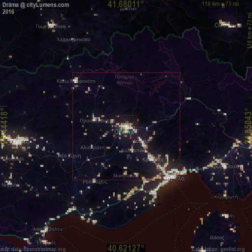

Analysis of Dráma night lights 2016
Square area 10x10 km:
 2.6%
2.6%90-99
5.03%80-89
3.41%70-79
3.08%60-69
4.06%50-59
7.31%40-49
2.27%30-39
3.08%20-29
3.73%10-19
43.99%0-9
21.43%Square area 50x50 km:
0.63%90-99
1.51%80-89
0.75%70-79
0.87%60-69
0.98%50-59
0.96%40-49
0.97%30-39
0.87%20-29
2.04%10-19
7.12%0-9
83.29%Clear (daylight) street map image can be seen on geolist.org.
Map coordinates:
41° 40' 48.4" North, 23° 26' 39" East
41° 9' 10.2" North, 24° 8' 50.3" East
40° 37' 16.6" North, 24° 51' 1.5" East
Some cities around Dráma sort by population:
• Sérres
50.8 km =31.6 mi,  261°
261°
• Kavála
32.2 km =20 mi,  137°
137°
• Xánthi
62.1 km =38.6 mi,  91°
91°
• Smolyan, BG
66.5 km =41.3 mi,  45°
45°
• Gotse Delchev, BG
57.5 km =35.7 mi,  323°
323°
• Chrysoúpolis
49.5 km =30.8 mi,  112°
112°
• Devin, BG
68.9 km =42.8 mi,  17°
17°
• Sidirókastro
64.1 km =39.8 mi,  278°
278°
736364 (p: 44,823)
Sources (retrieved 2019-11-25):
» Earth at Night: Flat Maps 2012, 2016