Sidirókastro night lights from space
Night Light of Sidirókastro (Central Macedonia) from space (Greece) Src. Average luminocity for 10x10km area is 10.3279% and for 50x50km: 5.6567%.
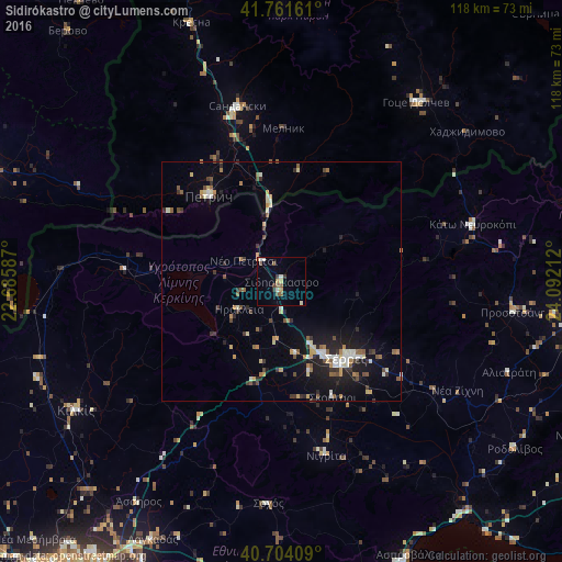
Analysis of Sidirókastro night lights 2016
Square area 10x10 km:
 0.81%
0.81%90-99
2.27%80-89
0.81%70-79
1.46%60-69
0.16%50-59
2.6%40-49
1.79%30-39
1.62%20-29
0.49%10-19
0.16%0-9
87.82%Square area 50x50 km:
0.41%90-99
0.98%80-89
0.59%70-79
0.68%60-69
0.52%50-59
0.95%40-49
0.71%30-39
0.95%20-29
1.14%10-19
3.6%0-9
89.47%Clear (daylight) street map image can be seen on geolist.org.
Map coordinates:
41° 45' 41.8" North, 22° 41' 9.1" East
41° 14' 6" North, 23° 23' 20.4" East
40° 42' 14.7" North, 24° 5' 31.6" East
Some cities around Sidirókastro sort by population:
• Sérres
21.3 km =13.2 mi,  141°
141°
• Petrich, BG
23.7 km =14.7 mi,  320°
320°
• Sandanski, BG
37.9 km =23.5 mi,  346°
346°
• Kilkís
50.8 km =31.6 mi,  238°
238°
• Gotse Delchev, BG
46.7 km =29 mi,  37°
37°
• Bosilovo, MK
59.7 km =37.1 mi,  292°
292°
• Novo Selo, MK
46.8 km =29.1 mi,  295°
295°
• Star Dojran, MK
56.2 km =34.9 mi,  264°
264°
734310 (p: 5,177)
Sources (retrieved 2019-11-25):
» Earth at Night: Flat Maps 2012, 2016