Chrysoúpolis night lights from space
Night Light of Chrysoúpolis (East Macedonia and Thrace) from space (Greece) Src. Average luminocity for 10x10km area is 19.869% and for 50x50km: 7.5932%.
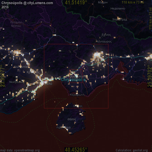
Analysis of Chrysoúpolis night lights 2016
Square area 10x10 km:
 1.02%
1.02%90-99
5.1%80-89
1.7%70-79
2.04%60-69
2.38%50-59
4.08%40-49
0.68%30-39
1.19%20-29
0.85%10-19
24.32%0-9
56.63%Square area 50x50 km:
0.55%90-99
1.42%80-89
0.87%70-79
0.86%60-69
1.06%50-59
0.8%40-49
0.94%30-39
1.11%20-29
1.91%10-19
6.26%0-9
84.23%Clear (daylight) street map image can be seen on geolist.org.
Map coordinates:
41° 30' 51.1" North, 23° 59' 26.8" East
40° 59' 8" North, 24° 41' 38" East
40° 27' 9.5" North, 25° 23' 49.3" East
Some cities around Chrysoúpolis sort by population:
• Kavála
24.6 km =15.3 mi,  258°
258°
• Xánthi
23.2 km =14.4 mi,  44°
44°
• Komotiní
61.5 km =38.2 mi,  76°
76°
• Dráma
49.5 km =30.8 mi,  292°
292°
• Smolyan, BG
65.5 km =40.7 mi,  1°
1°
• Zlatograd, BG
55.2 km =34.3 mi, 37°
• Madan, BG
60.6 km =37.7 mi,  19°
19°
• Nedelino, BG
61.5 km =38.2 mi,  31°
31°
735747 (p: 8,885)
Sources (retrieved 2019-11-25):
» Earth at Night: Flat Maps 2012, 2016