Kibi night lights from space
Night Light of Kibi (Eastern) from space (Ghana) Src. Average luminocity for 10x10km area is 4.8306% and for 50x50km: 2.4614%.
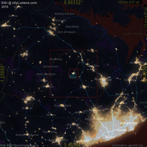
Analysis of Kibi night lights 2016
Square area 10x10 km:
 0%
0%90-99
0%80-89
1.45%70-79
1.03%60-69
1.03%50-59
0.62%40-49
1.03%30-39
0.21%20-29
1.65%10-19
0.83%0-9
92.15%Square area 50x50 km:
0%90-99
0%80-89
0.37%70-79
0.27%60-69
0.4%50-59
0.44%40-49
0.86%30-39
0.79%20-29
0.88%10-19
0.32%0-9
95.67%Clear (daylight) street map image can be seen on geolist.org.
Map coordinates:
6° 51' 48.7" North, 1° 15' 24.8" West
6° 9' 53.8" North, 0° 33' 13.5" West
5° 27' 55.6" North, 0° 8' 57.7" East
Some cities around Kibi sort by population:
• Koforidua
33.5 km =20.8 mi,  103°
103°
• Akim Oda
54.6 km =33.9 mi,  240°
240°
• Suhum
17.9 km =11.1 mi,  140°
140°
• Nsawam
45.5 km =28.3 mi,  150°
150°
• Asamankese
36 km =22.4 mi,  199°
199°
• Begoro
31.5 km =19.6 mi,  38°
38°
• Akwatia
31.4 km =19.5 mi, 243°
• Mpraeso
51.6 km =32.1 mi,  337°
337°
2299636 (p: 9,399)
Sources (retrieved 2019-11-25):
» Earth at Night: Flat Maps 2012, 2016