Bibiani night lights from space
Night Light of Bibiani (Western) from space (Ghana) Src. Average luminocity for 10x10km area is 8.7403% and for 50x50km: 0.829%.
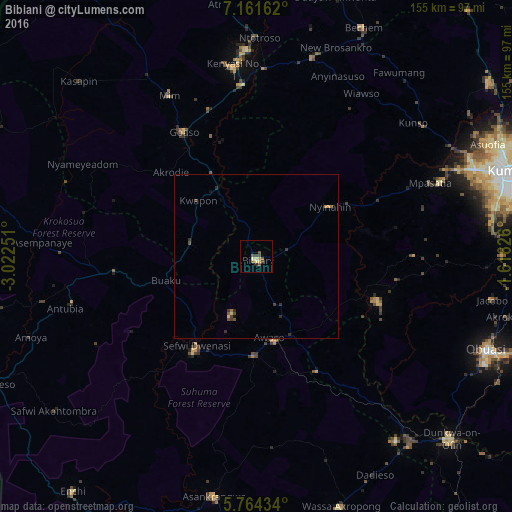
Analysis of Bibiani night lights 2016
Square area 10x10 km:
100  0%
0%
90-99 0.43%
80-89 2.81%
70-79 1.08%
60-69 0.87%
50-59 1.95%
40-49 2.38%
30-39 1.73%
20-29 0.87%
10-19 0%
0-9 87.88%
0%90-99
0.43%80-89
2.81%70-79
1.08%60-69
0.87%50-59
1.95%40-49
2.38%30-39
1.73%20-29
0.87%10-19
0%0-9
87.88%Square area 50x50 km:
100 0%
90-99 0.03%
80-89 0.16%
70-79 0.08%
60-69 0.14%
50-59 0.13%
40-49 0.29%
30-39 0.3%
20-29 0.18%
10-19 0.09%
0-9 98.6%
0%90-99
0.03%80-89
0.16%70-79
0.08%60-69
0.14%50-59
0.13%40-49
0.29%30-39
0.3%20-29
0.18%10-19
0.09%0-9
98.6%Clear (daylight) street map image can be seen on geolist.org.
Map coordinates:
7° 9' 41.8" North, 3° 1' 21" West
6° 27' 48.5" North, 2° 19' 9.8" West
5° 45' 51.6" North, 1° 36' 58.5" West
Some cities around Bibiani sort by population:
• Kumasi
80.7 km =50.1 mi,  71°
71°
• Obuase
77.6 km =48.2 mi,  111°
111°
• Sunyani
97.5 km =60.6 mi,  359°
359°
• Berekum
113.9 km =70.8 mi,  345°
345°
• Tafo
83.5 km =51.9 mi, 69°
• Dunkwa
82 km =51 mi,  133°
133°
• Duayaw-Nkwanta
82.7 km =51.4 mi,  17°
17°
• Bechem
76.9 km =47.8 mi,  25°
25°
2303060 (p: 19,076)
Sources (retrieved 2019-11-25):
» Earth at Night: Flat Maps 2012, 2016