Whittlesey night lights from space
Night Light of Whittlesey (England) from space (United Kingdom) Src. Average luminocity for 10x10km area is 9.8915% and for 50x50km: 7.0822%.
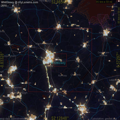
Analysis of Whittlesey night lights 2016
Square area 10x10 km:
 0.26%
0.26%90-99
1.32%80-89
0.53%70-79
0.26%60-69
1.46%50-59
0.93%40-49
2.25%30-39
2.51%20-29
5.69%10-19
12.43%0-9
72.35%Square area 50x50 km:
0.99%90-99
1.17%80-89
0.79%70-79
0.69%60-69
0.95%50-59
0.97%40-49
0.78%30-39
0.9%20-29
1.94%10-19
4.36%0-9
86.46%Clear (daylight) street map image can be seen on geolist.org.
Map coordinates:
52° 59' 0.3" North, 0° 49' 59.8" West
52° 33' 28.9" North, 0° 7' 48.6" West
52° 7' 42.5" North, 0° 34' 22.7" East
Some cities around Whittlesey sort by population:
• Peterborough
8.1 km =5 mi,  282°
282°
• Wisbech
23 km =14.3 mi,  58°
58°
• March
14.8 km =9.2 mi,  92°
92°
• Market Deeping
18.2 km =11.3 mi,  316°
316°
• Chatteris
16.8 km =10.4 mi,  132°
132°
• Yaxley
9.8 km =6.1 mi,  242°
242°
• Ramsey
12 km =7.5 mi,  173°
173°
• Sawtry
16.8 km =10.4 mi,  218°
218°
2634010 (p: 12,745)
Sources (retrieved 2019-11-25):
» Earth at Night: Flat Maps 2012, 2016