Sawtry night lights from space
Night Light of Sawtry (England) from space (United Kingdom) Src. Average luminocity for 10x10km area is 8.5341% and for 50x50km: 8.4904%.
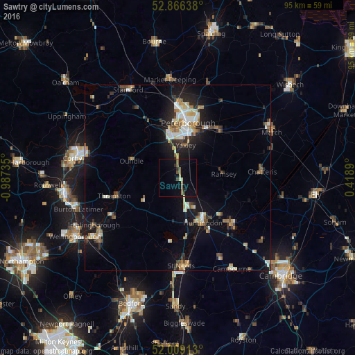
Analysis of Sawtry night lights 2016
Square area 10x10 km:
 0%
0%90-99
0.51%80-89
0.76%70-79
0.76%60-69
2.02%50-59
2.15%40-49
0.51%30-39
0.88%20-29
1.77%10-19
4.55%0-9
86.11%Square area 50x50 km:
1.09%90-99
1.33%80-89
0.98%70-79
0.84%60-69
1.13%50-59
1.04%40-49
1.01%30-39
1.1%20-29
2.1%10-19
6.2%0-9
83.18%Clear (daylight) street map image can be seen on geolist.org.
Map coordinates:
52° 51' 59" North, 0° 59' 14.5" West
52° 26' 23.4" North, 0° 17' 3.2" West
52° 0' 32.9" North, 0° 25' 8" East
Some cities around Sawtry sort by population:
• Peterborough
15.1 km =9.4 mi,  9°
9°
• Huntingdon
13.8 km =8.6 mi,  151°
151°
• Whittlesey
16.8 km =10.4 mi,  38°
38°
• Yaxley
8.8 km =5.5 mi, 11°
• Ramsey
11.9 km =7.4 mi,  84°
84°
• Thrapston
17.9 km =11.1 mi,  254°
254°
• Godmanchester
15.3 km =9.5 mi, 151°
• Oundle
13.2 km =8.2 mi,  290°
290°
2638473 (p: 5,252)
Sources (retrieved 2019-11-25):
» Earth at Night: Flat Maps 2012, 2016